
[rev_slider f-coal]
Sunlight filtered through the leaves of the forest canopy creating a mottled pattern that reminded me of woodland camouflage. It was beautiful, even if it made it more difficult to read the terrain ahead. I was on a tight winding trail moving between trees and trenches with roots sticking out the sides, following Kyle Buchter, of Rausch Creek Adventures, towards something new.
Starting out from the familiar trails of the off-road park, we were going to move outside the usual parameters to work on the kind of scenarios I might face during an expedition that relies on old maps of areas I have never seen. Not knowing if roads still exist, or what condition they may be in presents very different problems than driving complex obstacles on well-defined trails.
The location of Rausch Creek Off-Road Park, in the heart of the old coal fields that once covered this area of Pennsylvania, offered a unique opportunity to simulate the exploration scenario. Beyond the extensive property of the park itself, the region is criss-crossed with old mining roads, state game lands, hunting club property and another adjacent ATV park. Buchter knows the area intimately. He grew up nearby, with these woods as part of his youthful “playground.” And in addition to being an expert driving instructor certified by the International 4-Wheel Drive Trainers Association, he has taken a personal interest in the local history of the region. After researching the area’s mining legacies, Buchter obtained the permission of private landowners to uncover a series of old trails that connect two mountains. He has been systematically exploring the area ever since.
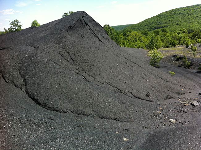
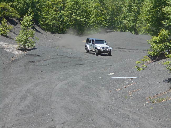
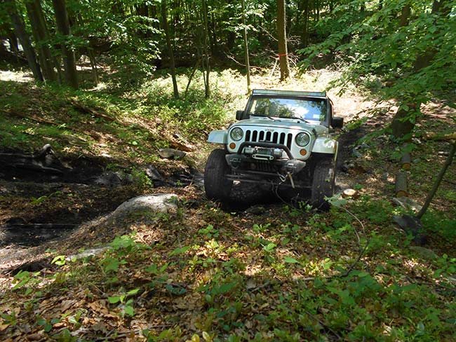
As we left the boundaries of the off-road park, we could still see clear trails that had been in use for many years, though they were lightly used and somewhat overgrown. Tall grass and tight brush meant we had to be more careful, moving out of the thicker part of the forest into a desolate wasteland of old pits full of the black coal silt. The remains of this industrial waste was piled up in small dune-like mountains. Though less grand and imposing than desert sand dunes, it had its own wonder. The silt behaved just like soft sand, and we had to keep moving fast or we would sink down into it.
It didn’t have the regularity and pattern that gives natural sand dunes their rhythm, but otherwise, the driving technique required was the same. Buchter explained that this “artifact” was actually a really big hole, that went about 40 feet down underneath, and was full of this debris. There was no “trail” through the silt, we just arched around the bowl, kicking up the coal dust which quickly trickled back down erasing our tracks as we moved onward.
I marveled at the black “dunes” hidden away in the midst of these woodlands and wondered what other traces of the mining past we would find on the land.
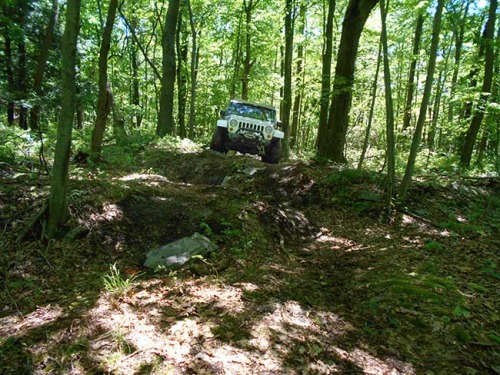
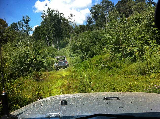
Heading to the site of a mine entrance dug into the side of the mountain, we were driving a “trail” that we could barely see. High grass and overgrown brush made it difficult to follow the “path.” It also made it impossible to see what obstacles lie ahead, or even the true contour of the ground below. The lack of visibility and the uncertainty of what was in front of us made a fairly easy section of trail quite challenging. Ground cover and moss contributed to the complexity. On a steep slope even small moss-covered rocks became a problem as the earth underneath was a rich loamy soil full of roots and decayed leaves that just sinks down and slips. My tires couldn’t get enough traction, and I struggled in spots to work my way over rocks that would have been “no big deal” on a regular trail.
Buchter was letting me pick my own lines and encouraging me to problem-solve my difficulties as I went, with just a suggestion here or there to get me to consider all my options. I was learning to assess the trail by feel as I drove, only stopping to scout when things got really “technical.”
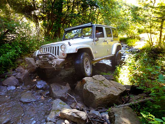
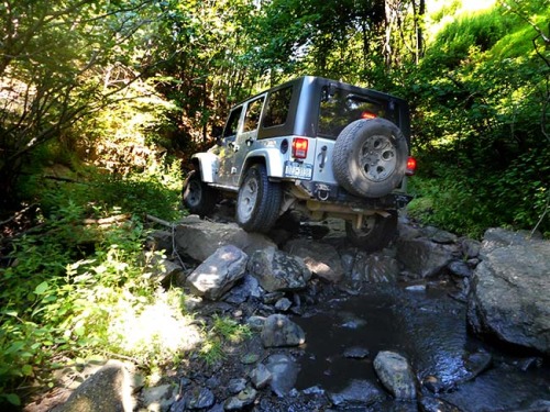
Approaching a creek, it did get “technical” — we weren’t going to “cross” it. We were going to have to drive in it, Buchter explained, using the creek as a “road” through this part of the forest so that we could get to the other side of an interstate highway that ran above. He eased his Jeep down into the water, moving forward a bit, then signaled for me to follow. The water wasn’t very deep, and for the most part we could see the bigger rocks sticking up. They would be our “path.” We worked our way from rock to rock, just as we would do on the rocky part of a trail. The only difference was that the flowing water discouraged scouting on foot, so I had to drive it by “feel.”
This was no time for me to get bold. I carefully followed Buchter’s line, seeing where his Jeep had trouble or slipped a bit and adjusting my approach accordingly. We continued along, and I was listening to the sound of the rocks beneath my Jeep shifting in the water, trying to decipher the different meanings, when I saw Buchter had stopped. I couldn’t see what was up ahead, as the creek was bending around, but I assumed there might be a big boulder or some other complex obstacle.
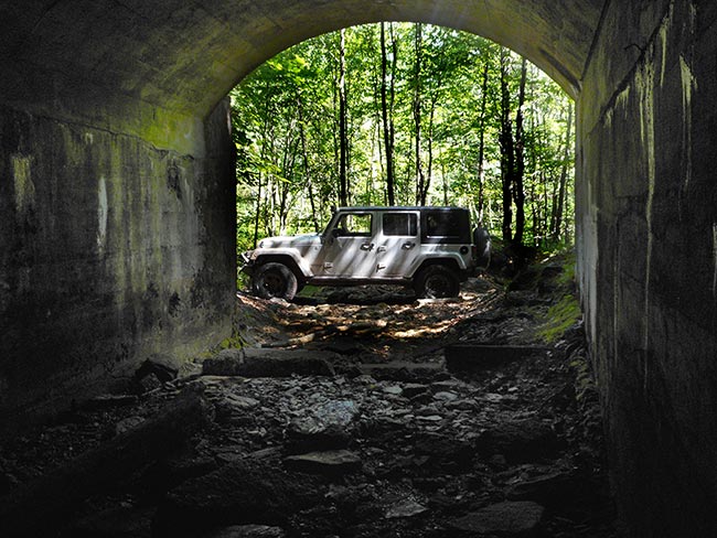
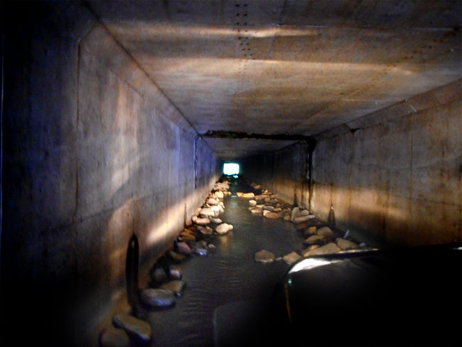
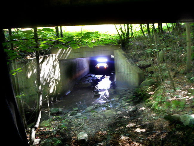
The narrow opening of a drainage tunnel seemed foreboding. A dark hole. Buchter had done this before and knew that it was passable. He told me to wait until he had gotten to the other side before entering, then his Jeep disappeared into the darkness. A few tense moments later he radioed for me to follow.
I cautiously entered the surreal space, listening attentively to the new sounds echoing off the walls that tightly surrounded my Jeep. There weren’t many rocks in the water, so the drive through was relatively smooth. Still, it was eerie and seemed long as a sensory experience of blackness, despite the vehicle’s lights.
The second tunnel was longer. And more technical. It was full of rocks. I was now dealing with water, darkness, rocks, and the limitations of tight space. I had to think in three dimensions. All while passing through the otherworldly environment of the tunnel. The sounds of water flowing, rocks being churned under my wheels echoed the length of the enclosure. Buchter reminded me to be careful the rocks I chose to climb up on did not tilt my Jeep into the wall, or snag my lightbar on the top.
I moved slowly. Deliberately. Each decision about where I placed a tire mattered. I could not get stuck in here. As I splashed slowly over rocks, one occasionally slipped out from under, clattering down deeper into the water. The sounds were larger than life. Time seemed warped, stretched out longer than reality as I drove towards the light ahead. A sigh of relief as I exited and climbed back up out of the water and on to the bank.
We continued onwards towards a piece of history hidden in the hills. After winding our way carefully along the hint of a thickly wooded path, we suddenly merged onto a clear flat and easy trail. Buchter explained that we were driving along what had once been a rail track taking coal from the mine to the main line of the Reading Railroad. There was no longer any sign of “track” or evidence that a train once ran here. The only “clue” we have is that it is perfectly graded and nice and flat in the middle of terrain that is most definitely neither of those things. I realize that looking for artifacts of history in a place that has been reclaimed by the forest is an exercise in noticing nuances.
While Buchter knew exactly where the mine entrance was, I was imagining what clues we might see that would indicate its presence. Looking at the rail bed we were riding on, I realized there would be no way to know it was a “rail bed” if you were not familiar with the historical accounts or hadn’t seen the older maps that show it. However, once you knew it existed, and roughly where, you knew what to look for, and then it became “clear” that the graded trail was “it.”
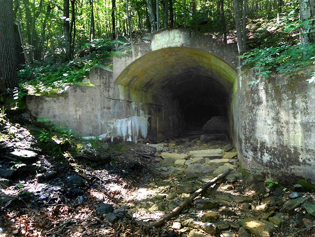
We were coming to a “clearing” of sorts, when Buchter stopped. As I pulled up next to him I saw it on my left. This was way more than a few artifacts, it was the entire intact mine entrance, wide open (and graffitied by local kids) for exploration. We went inside a little way, but we hadn’t brought headlamps and the interior of the mine was pitch black and cluttered with debris.
Pointing to the date and name of the mine etched on a cornerstone, Buchter shared a bit of the history he had uncovered. This mountain was riddled with a labyrinth of hidden tunnels burrowed deep into its sides that were just abandoned when the mining stopped.
Anything useful or valuable was long ago taken, so there were no “artifacts” to speak of that would make it seem “museum”-like in a historical preservation sense of the term. It was just a gaping hole, with the entrance masonry in tact, and yet it spoke volumes to the history of the region, and the lives lost in those mines once upon a time when this mountain was the center of a hub of activity, and the black coal it produced provided the livelihood for the surrounding communities.
Returning to the Jeeps, I quietly reflected on that history, those people, their stories, their struggles and their strengths, and wondered what other traces could be found here.
MORE ON TRAINING: Tactical Driving & Expedition Management | Coal Country: Uncovering Forgotten Trails | Lessons from the Rubicon | Pathfinding Across Terra Incognita | Scouting the Sahara in Morocco | US Nomads Go to Jeep School | Learning to Read the Clues on a Map | Navigating the Desert the Bedouin Way | Route Finding with Orienteering
Rausch Creek Adventures offers group and individualized training to provide drivers with a strong off-road skills foundation and enable them to drive their vehicles to the fullest potential. Rausch Creek Off Road Park is devoted to providing a fun, legal place for off-road enthusiasts to go four-wheeling. The park consists of almost 3,000 acres of easy, intermediate, and difficult trails featuring rocks, bowls, hills, club friendly trails, and free, on-site camping.
Rausch Creek Off Road Park is located in Pine Grove, in Schuylkill County, the heart of the anthracite Coal Region of Eastern Pennsylvania. It can be reached by Interstate 81 (exit 107, south via Route 209) or Interstate 78 (exit 13, north via PA-501).