
In preparation for a longer upcoming trans-Saharan journey we conducted a scouting trip in south-eastern Algeria during April 2017. We spent about two weeks traversing roughly 650 miles of desert, primarily off-road. Using the town of Djanet as a base point we looped southeast almost to the Libyan border, and then back north west to the Ihrir oasis. The journey was made in a locally-sourced Toyota Land Cruiser and focused on the UNESCO world heritage sites around Tassili N’ajjer. The primary goal of this mission was to assess terrain, security, driving conditions, logistical concerns and approximate timeframes for a future expedition.
< BACK: TO DJANET | ALGERIA REPORT HOME | AHEAD: TO WANTA BERKA >
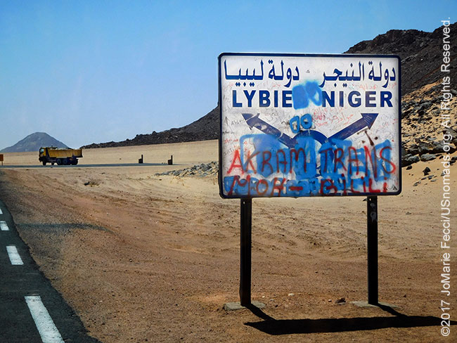
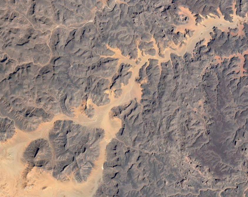
Leaving Djanet the vastness of the desert becomes apparent, broken only by ragged rock formations that mark our progress along the highway. We pass the turnoff for Niger and take the direction for Libya. A gold, black and blue color palette becomes the dominant motif as the tar ribbon of the N3 extends to the horizon. The road is mostly straight and empty, apart from an occasional big truck. The tall black walls of the Tassili plateau become our guide, as we follow its contours south and east. The plateau is the focal point of the Tassili N’Ajjer world heritage site which encompasses an area of 72,000 square kilometers, beginning north east of Djanet and stretching south to the Niger and Libyan border area. It includes the whole of the Tassili N’Ajjer mountain range, as well as the sands and dune areas in the extreme southeast of the country. Within these boundaries there exist more than 15,000 rock paintings and engravings, including some that are 12,000 years old. We are headed to an area south of the plateau itself, known as the Tadrart — a unique desert landscape with surreal rock formations, massive sand dunes and narrow canyons.
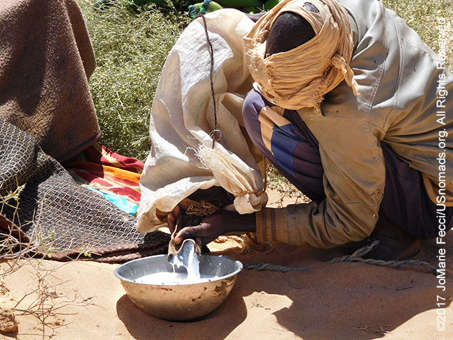
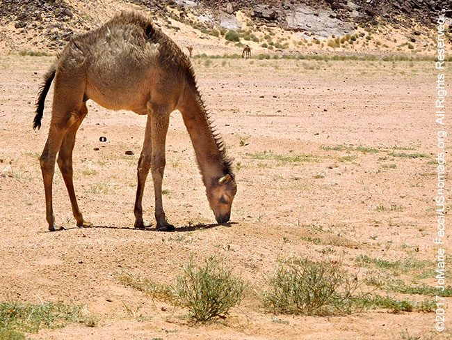
In what looks like the middle of nowhere an hour or so into the journey, we turn off pavement and follow a faint desert track to deliver some food supplies to a nomad. The young herder has been camped out alone with his camels in the emptiness. Though we were bringing him aid, he shyly poured a bowl of camel milk from a goatskin bag to welcome us in a traditional gesture of desert hospitality. The offer of milk to visitors is part of an elaborate social code that evolved over centuries as a function of life in a harsh and hostile environment. The obligation to provide hospitality was tied up with honor and survival in the desert. According to an old proverb, “In this world we are all strangers and travellers, guests of God.” Everyone recognized that he might one day be in need.
The traditional nomadic lifestyle is hard, and it is not surprising that given the opportunity, most people have chosen the much easier settled life of the towns. They prefer paid employment to herding camels in a harsh and unforgiving environment. The level of sedentarization among the Tuareg in Algeria is greater than that of their cousins in Mali and Niger, in part because of the differences in government policies between the three nations since independence. Prior to Algeria’s independence, the Tuareg lived in accordance with their ancient traditions, even after their territory was brought under French control. The French colonial policy in the Sahara did not encourage the large-scale sedentarization, as the available water resources of the oases were not adequate to support a large sedentary population and the cost of providing water and housing to nomads would have been exhorbitant. The Tuareg were left to their own devices, as long as they did not interfere with French administration.

Traditional Tuareg society was hierarchical with distinct castes and social roles. Nobles were warriors who did not engage in physical labor or farming. They spent their time protecting the caravan trade, hunting animals and raiding other tribes. Vassals looked after the nobles’ animals and provided meat, milk, and butter as well as military service in time of war. Slaves and “haratin” serfs were at the bottom of the social ladder, and could not own either land or water. They worked the nobles’ land and did the labor. In addition to these principal divisions, artisans and marabouts had their own group status.
Life began to change radically in 1962, with Algerian independence. The Tuareg social structure was in direct contradiction with the ideals of revolutionary socialism promoted by the national government. Slavery and serfdom were abolished and agriculture was organized on a co-operative basis, with land being declared “free” to those who worked it. Tuareg nobles lost power and wealth. At the same time, the new state was bringing in modern development–powerlines, schools and clinics–that benefited the whole community. A large majority of the people began to settle, and even those who kept up with a more traditional lifestyle tended to become “semi-nomadic.”
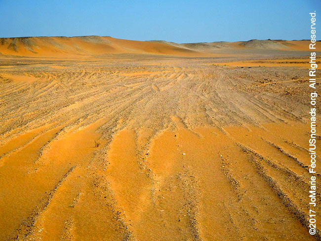
We continued heading southeast on the N3 until the pavement ended in a rough patch of road still under construction, which we followed for a while before finally turning south onto a desert piste. The terrain had changed to a huge stretch of barren sand. We aired down only slightly. The sand was pretty solid and granular, and we could move along at a fair pace. The black rock walls of the plateau were far behind us and ahead the desert was flat, with just a few low sand hills in the distance. There wasn’t a tree or blade of grass anywhere.
The desert is expanding, in part due to climate change, but also as a function of human intervention. The newer semi-nomadic rhythm takes more of a toll on the environment than the older nomadism did. Before people would move across long distances in search of grass — in dry years they might have to travel over a thousand kilometers to find pasture. They moved continually, following the rain and giving the grasses time to recover. Today, most move back and forth from homes in town, which can result in overgrazing of nearby pastures. Trees are cut for firewood. Grasses are eaten down to the root. There is nothing left to hold the sandy soil together and the wind does the rest.
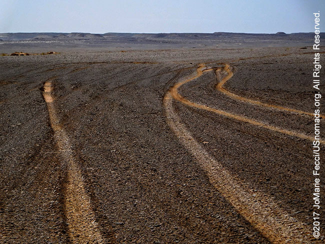
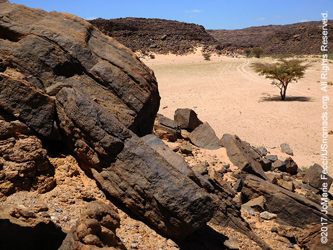
As we drive further south, the terrain begins to change again. Yellow sand is replaced by black gravelly rock known as “reg“. Sometimes called “desert pavement” because it can at times almost seem like a road, reg is typically found on top of alluvial fans. Here it is an almost solid surface of closely-packed rock fragments darkened by “desert varnish” and is easy driving. Much of the Sahara is made up of alternating bands of “reg” and “erg” (as the soft sand seas are known), interrupted by upcroppings or rock escarpments, like the Tassili plateau. It is said that the desert never remains totally flat for long, and true enough, we can see low cliffs or hills in the distance.
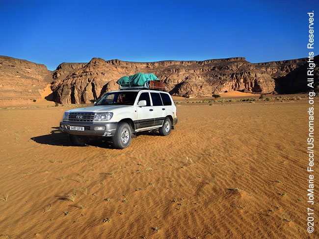
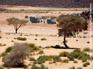
There are only two entry points leading into the Tadrart, and we have chosen to take the lesser used one. Turning to the east from the oued we have been following, we are looking for a narrow passageway between the cliffs. The folds of rock seem to open up as we approach, revealing a greener place hidden behind the sheer faces of eroding sandstone walls. An army checkpoint is strategically placed in the shade at the narrowest spot. It is a small unfortified outpost and the soldiers on duty seem fairly relaxed as they check our authorization papers. There are not any major security issues in this area, but the military positions are a deterrent for smugglers. The Djanet to Ghat route was once a favorite for illegal immigrants from sub-Saharan Africa headed to Libya and Europe beyond, though that traffic has slowed.
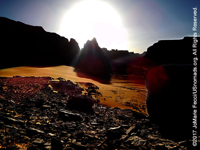
A few camels grazed near the soldiers’ position. The grass looked lush here in comparison with the desolate landscape we had just driven through. The narrow part of the canyon we were entering is known as El Berdj. Tall black rock walls surrounded us, and the soft golden sand was dotted with bits of green vegetation. The terrain seemed confusing with lots of turnoffs into dead-ends deeper between the rocks and not so many clear tracks to follow. But the desert’s beauty was magnificent as the sun began to set.
> CONTINUE: THE JOURNEY TO WANTA BERKA
< BACK: TO DJANET | ALGERIA REPORT HOME | AHEAD: TO WANTA BERKA >
WHERE WE ARE
The People’s Democratic Republic of Algeria, in North Africa is the largest country in Africa and the tenth-largest country in the world. With an area of 2,381,741 square kilometres (919,595 sq mi) it is one-quarter of the size of the entire United States and four times the size of France. Its capital and most populous city is Algiers, located in the country’s far north on the Mediterranean coast. It is bordered to the northeast by Tunisia, to the east by Libya, to the west by Morocco, to the southwest by the Western Saharan territory, Mauritania, and Mali, to the southeast by Niger, and to the north by the Mediterranean Sea. With a population of roughly 38,813,722, Algeria ranks 33rd in population worldwide. The majority of that population, which is a well-integrated mixture of Arab and indigenous Berbers, live in the northern, coastal region. The official language is Arabic though many people also speak French and/or one of the nation’s Berber dialects.
ABOUT THE DAY’S ROUTE
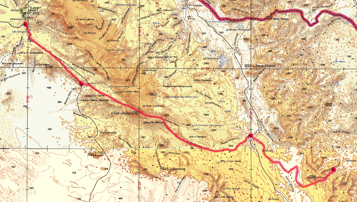
DJANET TO EL BERDJ – 120 miles –
(click map to view larger image)
The drive starts from Djanet, via the N3 southeast for roughly 80 miles, mostly on pavement, which gets a bit rough, then becomes a graded dirt road the rest of the way. The navigation to this point is easy as it is following the only highway for a straight shot (just need to be sure to bear left following the sign for Libya, rather than turning south for Niger at that crossroad). After turning off the N3 into the desert there is another 40 miles to go and here the navigation becomes much more critical, following tracks, that are sometimes not so clear. The terrain alternates between solid sand, more gravely sand, and “reg,” a rough rocky surface, and some soft sand once within the walls of the Tadrart. The route follows a system of oueds southward, before turning east into the gap in the cliffs to enter the maze of canyons.
TERRAIN DETAIL: EL BERDJ
(click map to view larger image)
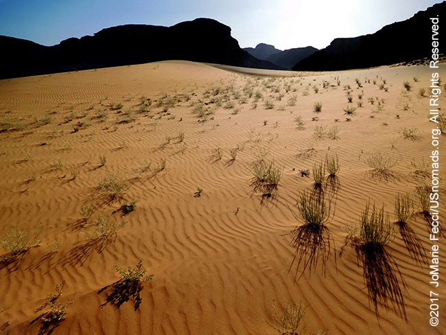
The area of the Tadrart known as El Berdj starts at a narrow canyon cut into the surrounding sandstone rock, and branches out into a maze-like area of off-shoots as it winds eastward. The floor of the canyon is mostly softer sand, but solid enough for easy driving without airing down further. There is some vegetation along the centerline of the oueds, and rock-spill from erosion of the canyon walls, near the edges. In some spots there is a unique combination of black and yellow sand, and also occasional soft sand hills or single dunes where wind has blown the sand up against the wall in narrower parts of the canyon.
MAP RESOURCES
For general planning, a good overview map of Algeria that includes the southeast is this ITBM Algeria 1:2,000,000 scale road map. For detailed navigational planning we used the old Russian 1:500,000 topos that circulate online supplemented by US 1:250,000 tactical pilotage maps from the Perry-Castañeda Library Map Collection of the University of Texas at Austin. Note that these maps are “historical” and marked “not to be used for navigational purposes” but they make an excellent planning tool, as the basic topography does not change. For more on available maps for this part of Algeria and the Sahara generally, see the Sahara-Overland.com map page.
DRIVING IN ALGERIA
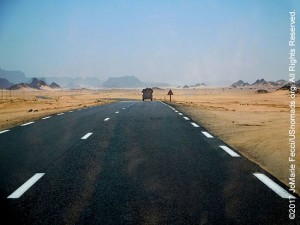
In general, visitors are allowed to drive in Algeria with their national driver’s license during stays of three months or less, but those planning to stay longer should obtain a separate international driver’s license. If bringing a vehicle from outside Algeria, drivers will also need proof of insurance, proof of ownership and their passport. The speed limits are 80 km/h on open roads, 50 km/h in towns and 110 km/h on highways. Expect to encounter police and military checkpoints on major roads within/around Algiers and other major cities. Checkpoint protocol is to turn off your headlights when approaching a checkpoint at night. Stop and wait for police or military to approach or signal you to move forward. Algeria has a vast transportation system with a fairly well developed infrastructure. There are 71,656 kilometers of paved roads including 1394 kilometers of expressways and 32,344 kilometers of unpaved roads for a total road system of 104,000 kilometers. The road system is a combination of primary routes, known as routes nationales (RN), and secondary roads, or chemins de wilaya (CW). In addition there are tertiary but generally accessible roads and tracks known as chemins communaux (CC), mainly serving rural areas in the north and in the Sahara region. The north, where the majority of the population resides, is well connected by the modern network of highways. The three major east-west highways are all in the north, running from Morocco to Tunisia. In the Saharan zone there is less inter-connectivity, but highways do cover the three major north-south routes. A “Trans-Sahara Highway” was conceived in 1962 as a transnational highway project to pave, improve and ease border formalities on the old trade route across the Sahara (from Algeria via Niger to Nigeria). Construction began in the 1970s, but the regional security situation currently precludes it as an option for overland travelers. Recent reports say the 625 km paved segment from Algiers to Ghardaia is in good condition, the 1291 km paved section from Ghardaia to Tamanrasset is in poor condition, the 400 km section from Tamanrasset to In Guezzam can be done in a 2WD vehicles, with the last 28 km from In Guezzam tothe Niger border post at Assamaka a soft sand track that is not recommended for 2WD. However, it is impossible to use this as a true North-South route at the moment, since the southern half from Tamanrasset to In Guezzam on the Niger border was sealed for security reasons in 2007. And the Algerian military typically stops foreign overlanders from going further south than In Salah on their own. Any overland travel in the southern regions may require a permit issued by the Algerian government. According to the US State Department recommendations drivers should be aware that Algeria has a very high vehicular accident rate. While emergency response resources are adequate in Algiers and other populated cities, this is not the case in rural areas. The emergency number in Algeria is 17 from a landline for the police, 14 for an ambulance and fire service. From a mobile all can be called by dialing 112.
DESERT HOSPITALITY
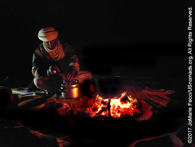
In the tradition of the Sahara hospitality was a matter of honor. Bedouin hospitality traditionally lasted three days. If any traveller stopped near your tent, you should go out and welcome him offering a bowl of camel milk, and then invite him to enter. You would feed your guest and he could stay with you for three nights, after which you could ask him politely where he was going and if you could help him on his way. That would be his signal to move on. And if he were an enemy (or a man you intended to rob) you would be unable to attack him for three days — for as long as he held your food in his stomach! In the same way, it was also considered fairer to raid another tribe at sunrise, since this would allow them a whole day to follow your tracks and try to win their camels back!
CAMEL MILK
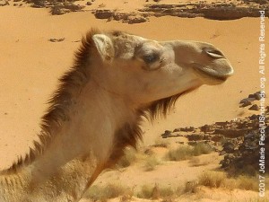
According to FAO statistics, there are 19 million camels worldwide, and the animal is an excellent source of milk. Camel milk has supported Bedouin, nomad and pastoral cultures since the animal’s domestication millennia ago. Today most camels are kept by pastoralists in subsistence production systems. They are very reliable milk producers during dry seasons and drought years when milk from cattle, sheep and goats is scarce. Camel milk is considered a very healthy drink because of low fat and cholesterol level. It has higher amounts of potassium, magnesium, copper, iron, zinc, and vitamin C, compared to cow milk. Further, it contains enough nutrients to sustain a person throughout the day without consumption of any other foods. Herders may for periods survive solely on the milk when taking the camels on long distances to graze in desert and arid environments. Camel farming, by utilizing a native species well-adapted to arid regions, able to eat salty desert plants, has been linked to de-desertification by UNESCO.
ABOUT REG
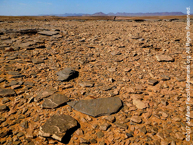
There are a few different theories to explain how reg is formed. The most common theory suggests it is the result of the gradual removal of sand, dust and other fine-grained material by the wind and intermittent rain, which leaves only the larger fragments behind. The larger fragments settle, forming a “pavement” which acts as a barrier to resist further erosion. Another theory attributes their formation to the shrink/swell properties of the clay below, reacting to precipitation and dryness. Finally, a newer theory proposes that the soil has been built up, not blown away, preserving a long history of dust deposition beneath them.
SMUGGLERS AND MIGRANTS
One of the main reasons for the security checkpoints and military presence around Djanet is to attempt to control trans-Saharan smuggling, which has, in some ways, taken the place of the old caravan trade routes that used to cross this part of the desert. “Afrod” (derived from “la fraude,” the French word for “cheating” or “smuggling”) began in the 1960s, first via camels, then with Land Rovers and, since the 1980s, with Toyotas. It grew up around an informal “public transportation” system that served Tuaregs travelling between Mali/Niger and Libya/Algeria. In addition to moving people, drivers would smuggle subsidized staple food (milk powder, macaroni, tomato paste, oil, sugar, etc.) and cheap fuel from Algeria into Mali/Niger. During the great droughts of the 1980s and the regional security situation in the 1990s, afrod became increasingly important as families fled north from Mali and Niger to find refuge in Algeria and Libya. According to Dr. Ines Kohl, of Sahara Connected, the perception of afrod by the local Tuareg population has changed. Once considered a somewhat prestigious business, afrod is now seen more negatively in the atmosphere of the current political and security circumstances. This transportation structure has increasingly become used by African migrants on their way to Europe. According to an Altai Consulting report, in 2014, 170,664 people arrived in Europe via routes fed by the Niger-Libya traffic. There are two main routes for migrants in this zone today, “afrod” and “transa.” “Afrod” is the primarily Tuareg-run route from Agadez, Niger, via Tamanrasset and Djanet in Algeria to Ghat in Libya. Typically it involves a convoy of Toyota pickups, carrying about 30 passengers each over a 1,000 kilometer route which takes 3 days. “Transa,” organized by Arabs, Hausa and Tebu, is the more common route. It is a large truck route from Agadez via Dirkou in Niger to Gatrun and Sebha in Libya. This route takes 1-2 weeks to cross the Sahara, with over 100 passengers loaded onto a single truck. Transa passes through military checkpoints where a “transit duty” is paid, making it semi-official.
NOTE: This is the second in a series of segments highlighting details of a two-week scouting trip in the south-east of Algeria. All text and photos are copyright JoMarie Fecci/USnomads unless otherwise noted. If you would like to use any imagery here, please contact us for permission. The trip was conducted in April 2017 by JoMarie Fecci of US Nomads with a local Djanet-based team. For more information about the specifics contact us.