
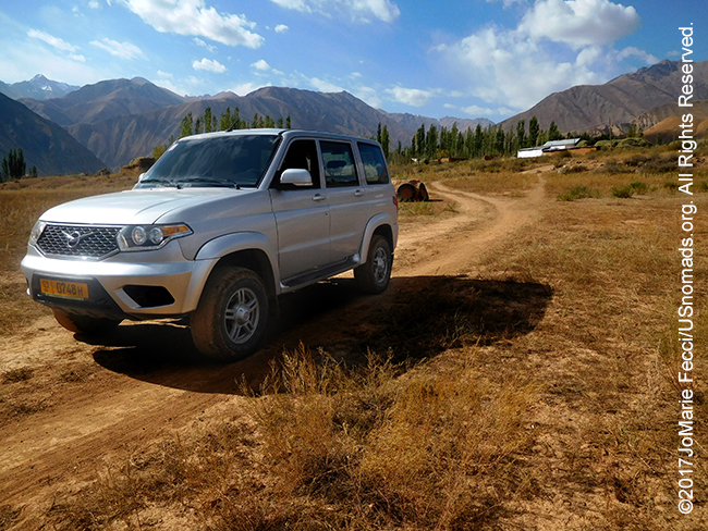
This 820-mile solo scouting trip in Kyrgyzstan was conducted in a Russian UAZ patriot sourced locally from Iron Horse Nomads in Bishkek in late September/early October 2017. The journey took a little over a week, and looped south from the capital as far as as the old silk road caravanserai of Tash Rabat near the Chinese border, then back up along the southern shores of lake Issy Kul. The goal of this initial recce was to lay the groundwork for a longer and more ambitious journey tentatively scheduled for the summer of 2018. This first trip focused on an introduction to some different nomadic cultures and to challenges of mountainous terrain and high elevations typical of much of the ancient Silk Road routes through Central Asia…
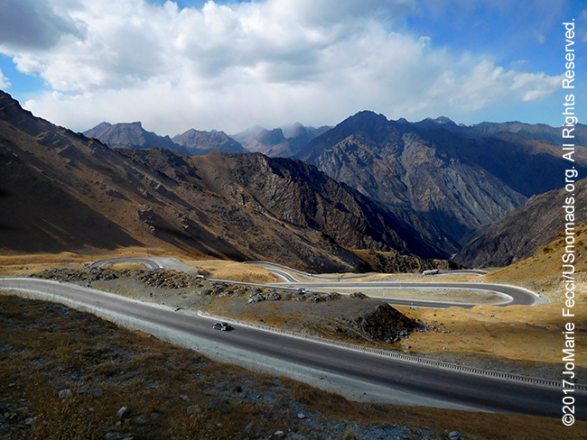
Getting away from the urban sprawl of Bishkek was not so easy, as the chaotic traffic of Kyrgyzstan’s crowded capital city continued all the way to the turn-off for the M41, otherwise known as the Pamir Highway. But once headed south, towards the mountains, and the Suusamyr valley beyond, the road opened up into a ruggedly beautiful landscape. Though still in the Chuy region which is generally considered the most developed part of the country, the area beyond the main population concentration of the capital quickly becomes a montage of majestic mountains. The road is well-maintained and at first glance it seems possible to make quick progress to the other side.
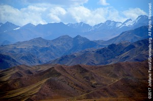
Of course, on the “other-side” lie more mountains. Kyrgyzstan is covered in mountains. In fact 90% of the terrain is mountainous with an average elevation of 2,750 meters. Driving here is an unending progression of climbing and descending, discovering new landscapes nestled in valleys and seemingly endless varieties of mountain terrain, from gentle slopping hills to harsh rugged rock. In between there are beautiful alpine lakes and rushing rivers. It is a landscape of contrasts. A journey through magnificence with surprises at each turn.
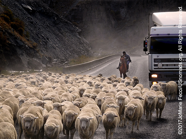
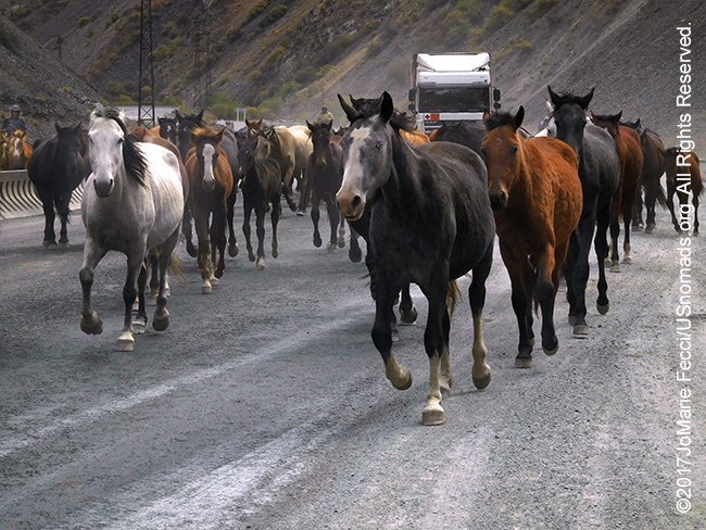
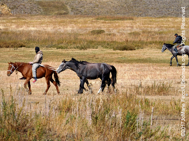
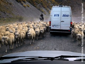
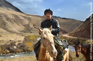
Progress begins to slow as the road begins to climb and sheep spill onto the highway like a flood, surrounding a giant tractor trailer truck freezing it in place. All mechanized movement halts as the animals swarm around vehicles in a surge of white fluffiness propelled forward by two herders on horseback trying to keep the animals together. As the last straggling sheep catch up to the group the trucks can begin moving again until a herd of horses moving at a fast pace, kick up a cloud of dust as they pass between the large trucks and Marshrutkas (shared taxi-vans) heading for the pass. All the way up the mountain this scenario repeats, periodically reducing traffic to a slow-ish stop-and-go snaking its way up to higher altitudes.
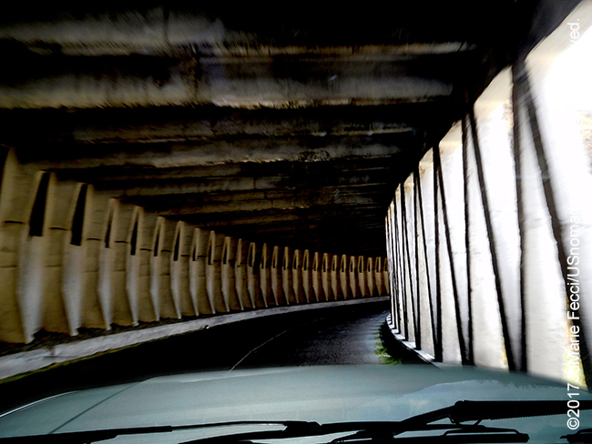
The vehicle-animal traffic jams are particularly numerous here at summer’s end as the herders are moving their animals to lower elevations for the winter, and with the Too Ashoo pass being the only way down, bottlenecking is inevitable. Töö Ashuu, literally means “camel pass”, and the crossing over part of the Kyrgyz Alatau range of the Tien Shan mountains is at an elevation of 3,130 meters about 120 km from Bishkek. At this altitude the wind adds to the chill in the air and there is snow on the mountain tops. Near the high point a 2.7-km-long (1.7 mi) tunnel enters the mountain at 3,130 meters on the north side and comes out at 3,180 meters on the south side. Leading up to it is a series of steep switchbacks, which as we get increasingly higher up, are more frequently spotted with cars and trucks pulled over on the side, hoods raised, sometimes with drivers underneath wrenching something or other.
During the month of September the government actually institutes a traffic plan to facilitate the movement of massive herds of animals through the Ashuu Too tunnel as herders move from summer pastures to lower elevations. The long tunnel is the only way across the heights and the scheme has scheduled alternating blocks of time for animals and trucks each day, with passage regulated by conductors on either entry to the tunnel who coordinate the complex choreography.
The tunnel itself is narrow with just two lanes, only wide enough for a car and a truck to pass in opposite directions with care. There are no lights, and driving deeper into it the blackness seems infinite and there is a strange sense of an endless void that makes the passage seem much longer than it probably is. When there is finally a slight lightening of the blackness, indicating an eventual “light at the end of the tunnel” there is an unconcious sigh of relief. The weather on each side of the tunnel can be drastically different.
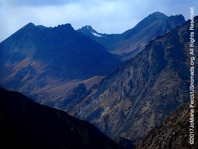
Descending the mountain is another series of sharp steep switchbacks, and at the bottom is the turn off into the valley. Snow can be seen on the mountain tops, but the rough rugged rocky terrain of the mountains gives way to gentle grasslands of the Suusamyr steppe plateau stretching out below. The Parmir Highway continues heading west over even higher mountains, eventually reaching Afghanistan, but the route to Kyzyl Oi goes south, towards China, into the golden glow of the valley. A nicely graded wide dirt road runs across the flat prairie where horses and cows graze peacefully.
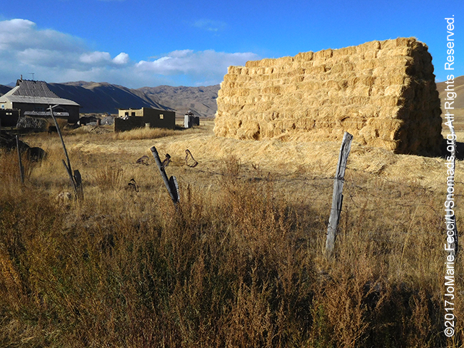
The Suusamyr region with its wide grasslands sits at an altitude of 2,000-3,200 meters between the ridges of Kyrgyz and Talas Ala-Too in the Inner Tien-Shan Mountains. Its pastures are considered among the best in Kyrgyzstan. Deep drifts of winter snow nourish an alpine meadow that in summer is carpeted with tall green grass, making for a lush jailoo. For centuries nomadic herders would fatten their sheep for winter here, sometimes even fighting among themselves over particular pastures. Under the Soviet regime, the nomads were encouraged to settle into village life and the area was almost exclusively given over to herds from the collective farms. Around four million sheep grazed here each summer, but the collapse of the collective farm system with the end of the Soviet Union dramatically impacted the region and herds today are only about a fifth of their original size. Most of the population is still actively involved in herding and lives a partially nomadic lifestyle, though land-use in the valley is a little more diverse now, with honey-production and potato and vegetable cultivation supplementing the traditional livestock.
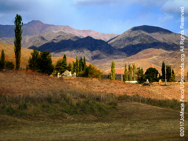
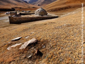
The dirt and gravel road crosses the Suusamyr river winding through small villages that are really just a gathering of a few isolated farmhouses in a vast dramatic landscape. Just before reaching the jagged mountains on the other side, at the far end of the village of Kojumkul, a strange memorial yurt stands alone, slightly askew. The site is a monument to Kyrgyzstan’s strongest man, a local hero named “Kojumkul.” Well-known for his strength and wrestling prowess, Kojomkul at over seven feet tall was a giant of a man. His generosity was also legendary. Unbeatable in the ring, he would share his prize winnings — sheep — amongst the poorer villagers, and during the Second World War it is said his wife, Akmadai, prepared food for the village whenever Kojumkul returned from a successful hunt. He died in 1955 at the age of 66 and the village is named in his honor. His memory is still revered here and some locals say it was Kojomkul’s spirit that protected them when an earthquake hit in 1992, badly damaging property throughout the valley but claiming no lives.
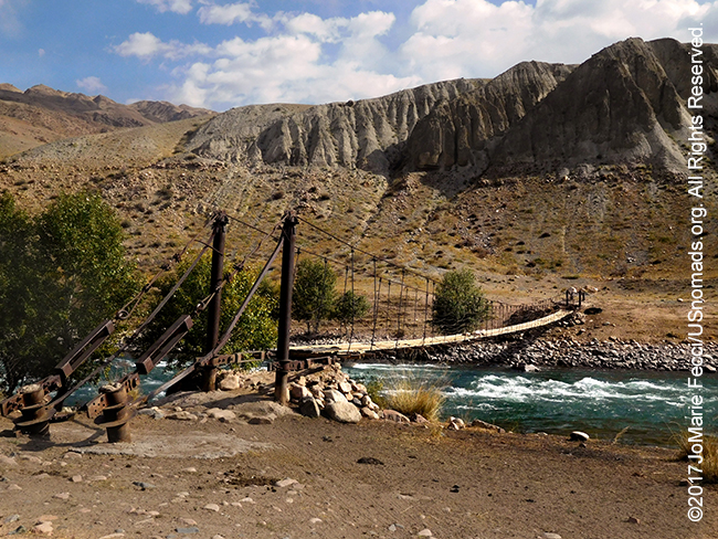
Beyond Kojumkul the road enters a foreboding steep-sided gorge cut by the fast-flowing Kokomeren River. Formed by the confluence of the Suusamyr and Karakol rivers, the Kokomeren glistens in the shadow of the mountain. Kyrgyzstan is relatively well watered, thanks to a topography marked by sharply uplifted peaks separated by deep valleys. The country has 6,500 distinct glaciers estimated to hold about 650 billion cubic meters of water with the high mountains functioning as moisture catchers. Small, rapid, runoff streams flow down from the peaks, joining to form larger rivers. Though none of the rivers are truly navigable, they keep the land lush and there is plenty of water resources for the herds. Experienced paddlers with their own equipment can enjoy kayaking the Kokomeren with a class 4-5 gorge along the upper section of the river and occasional class 4 rapids on the lower half. The best time for running the rivers here is late summer.
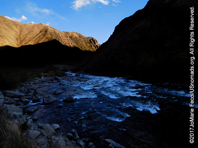
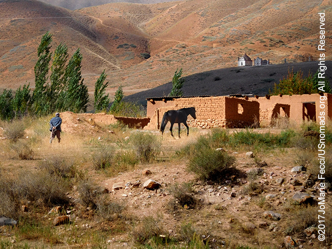
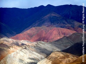
The road follows the river closely where the passage narrows in places until the rock walls open up into a calm “bowl” surrounded by high red mountains that protect a village hidden between its folds. Kyzyl Oi means “Red Bowl” in Kyrgyz and the village is named for the red rock that encircles it. It has an interesting history as one of the only Kyrgyz villages to have existed prior to the Soviet-era collectivization which forced nomads into village settlements. From the main road it seemed modern, in the sense that all the villages here seem “modern” but simultaneously “timeless”, and was well kept with a tree-lined main street and lots of nice neat homes tucked in along the sides.
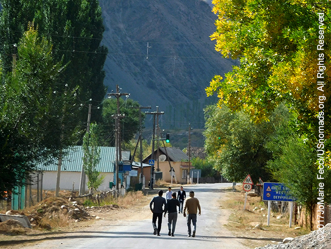
Village life in Kyrgyzstan still follows an agricultural rhythm, and Kyzyl Oi seems content in the natural richness of a fertile mountain valley, even if like for many villages here, the economic situation is not easy. There is a trickle of tourism money that comes into the village, but Kyzyl Oi is not on the biggest tourist routes and despite the very genuine hospitality of the villagers, visitors are rare in the winter season. Difficult access across the mountains and long harsh winters combine to keep the region isolated and relatively poor. Animal husbandry and subsistence farming remain the principle economic activity here, and while tourism is only a small part of the national economy (1.4% of GDP in 2016, according to the World Travel and Tourism Council), in places like Kyzyl Oi, it can be an important resource to help rural families supplement their incomes.
The Kyrgyz are well-known for their hospitality and the homestay experience for travelers here offers a great opportunity for a mutually beneficial exchange. The families that open their homes to guests are happy to share their culture and the homestay is an excellent way to comfortably connect with local people, taste real good home cooking and get current information about the area. A well developed “Community-based tourism” network strives to foster development of sustainable rural tourism that improves the living conditions of people in remote regions, while protecting and preserving the natural environment and local culture. And while the CBT association is useful, there are also plenty of opportunities to find homestays unaffiliated with the organization.
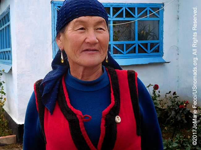
In Kyzyl Oi there is a warm welcome and residents take great pride in their history as one of only a few villages that existed prior to collectivization. With a strategic location protected by the mountains, the village served as a fortified position during the “Urkun” (which means “exodus” in Kyrgyz) in 1916, holding out long enough for many people to escape to safety in China. There is relatively little documentation of the details as it was not included in Soviet histories, but it happened as Tsarist Russia was crumbling. The Russian Empire had annexed the Naryn region of Kyrgyzstan in 1874. Conquest impacted the traditional way of life as Slavic “colonists” began to occupy land. In a push for economic development new towns were established. Cotton grew where once nomads grazed their herds, and railroads linked the area with markets in Russia. The nomadic Kyrgyz, Kazakhs, and Turkmens were especially resentful of the evolving changes. When a 1916 order of conscription into the Tsarist army ended the exemption of Muslims from military service, much of Central Asia rose in a revolt fueled by growing anger over losing the grazing lands.
The revolt was brutally repressed and some of the Turkic peoples continued to resist “Russian” rule under the Bolsheviks into the 1930s. Some estimates say that at least 150,000 Kyrgyz were killed by tsarist troops during the Urkun, while hundreds of thousands fled to the Chinese province of Xinjiang. According to Newcastle University’s Nomadic Settlement in Kyrgyzstan report, around a third of all Kyrgyz in the area fled to China as a consequence, though some would return once the Soviet regime instituted new policies. What began as an anti-tsarist movement morphed into a rallying ground for opponents of Russian or Bolshevik rule from all parts of the region. Peasant unrest already existed in the area because of wartime hardships and the Red Army’s harsh treatment of local inhabitants in 1921 drove more people into the resistance camp. The Russians applied a derogatory term, Basmachi (which originally meant brigand), to the indigenous resistance movement. The whole period from 1916 to 1931 is referred to as the Basmachi Rebellion, though the Red Army had the territory under control by 1920, and Soviet authorities soon mitigated the policy allowing traditional Kyrgyz culture to flourish again by the mid-1920s–even promoting local native leadership in the region.
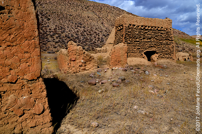
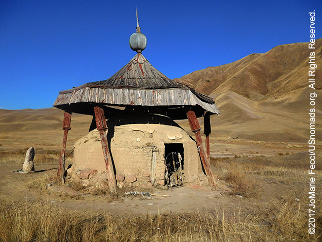
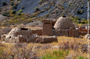
The cemetery on the edge of Kyzyl Oi is testament to the long history of the village. Elaborate traditional earthen tombs still stand side-by-side with those from the communist period in this “city of the dead.” Kyrgyz cemeteries really do look like small cities on the horizon from a distance. It is interesting because as a historically nomadic people they didn’t typically build permanent structures, but the oldest graves are built like small palaces of mud brick with intricate designs and complicated domes — almost as if the nomads put all their effort into constructing a final resting place. Many of these older tombs are now crumbling and in disrepair, and they are surrounded by more modern graves — some of which continue the tradition of elaborate construction while others are more discrete and simple in a modern style. Walking among the graves, one can’t help but ponder the contradictions of a complex culture where nomadic peoples built ornate “permanent homes” for their dead.
The cemetery lies across from the river bank at the foot of a mountain demarcating the limits of the village. It is a peaceful place surrounded by the rugged beauty of mountain wilderness waiting to be explored. There are footpaths and horse trails that go up into the hills and locals are happy to provide horses or show visitors the way. It would be easy to spend a few days here following the timeless rhythms of rural life while just getting to know the landscape.
COMING SOON: THE JOURNEY TO SONG KUL
WHERE WE ARE
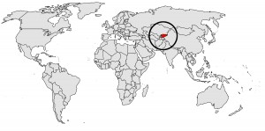
The Kyrgyz Republic is a landlocked country in Central Asia, bordered by Kazakhstan to the north, Uzbekistan to the west and southwest, Tajikistan to the southwest and China to the east. The smallest of the Central Asian states, Kyrgyzstan is about the same size as the state of Nebraska, with a total area of about 198,500 square kilometers. Its capital and largest city is Bishkek. Characterized by mountainous terrain, Kyrgyzstan has been at the crossroads of several great civilizations, most notably as part of the Silk Road caravan routes. Though long inhabited by a succession of independent tribes and clans, Kyrgyzstan has periodically fallen under foreign domination and attained sovereignty as a nation-state only after the breakup of the Soviet Union in 1991. Ethnic Kyrgyz make up the majority of the country’s 5.7 million people, followed by significant minorities of Uzbeks and Russians. Kyrgyz is closely related to other Turkic languages, although Russian remains widely spoken and is an official language, a legacy of a century of Russification. The majority of the population are non-denominational Muslims. In addition to its Turkic origins, Kyrgyz culture bears elements of Persian, Mongolian and Russian influence. However, many aspects of ancient Kyrgyz culture have been preserved due in part to the geographical isolation provided by its high mountain terrain.
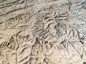
THE JOURNEY SO FAR
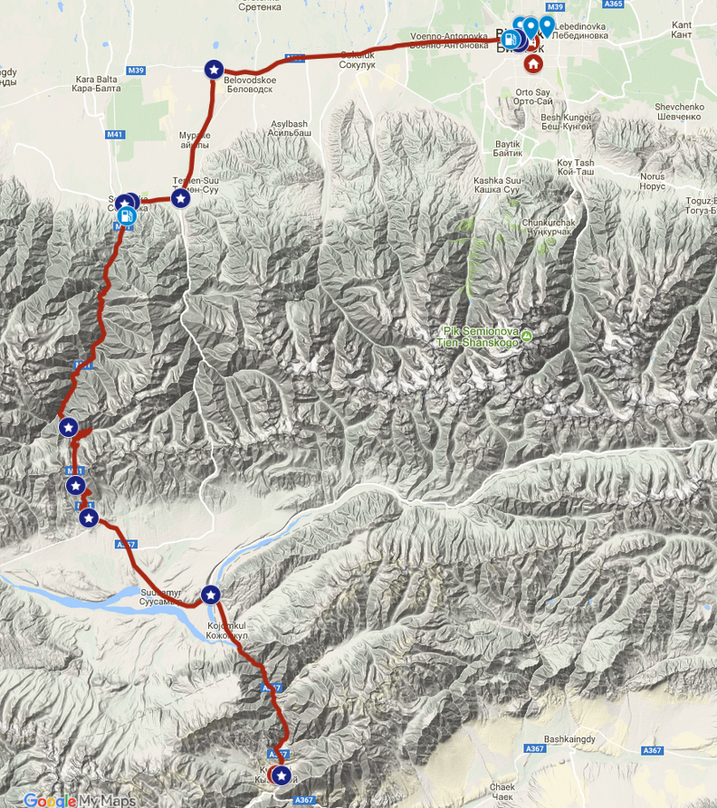
This map shows the progress of the journey around Kyrgyzstan from the starting point in Bishkek. The trip so far has covered roughly 119 miles.
ABOUT THE DAY’S ROUTE
BISHKEK TO KYZYK OI – 119 miles –
(click map to view larger image)
Today’s drive starts in the congested center of Biskek and continues westward through the chaotic traffic of urban sprawl for roughly 45 miles, before heading south on the famed M-41, known more commonly as the “Parmir Highway”. This section of the highway is a nice paved road that starts off straight and flat before beginning the steep climb up a series of switchbacks to an elevation of around 8,000 feet. The M-41 is moderately congested with heavy truck traffic and animal herds moving from summer to winter pastures during this season. After crossing the mountains the route descends into the Suusamyr valley and continues south to the village of Kyzyl Oi, nested between another series of mountains.
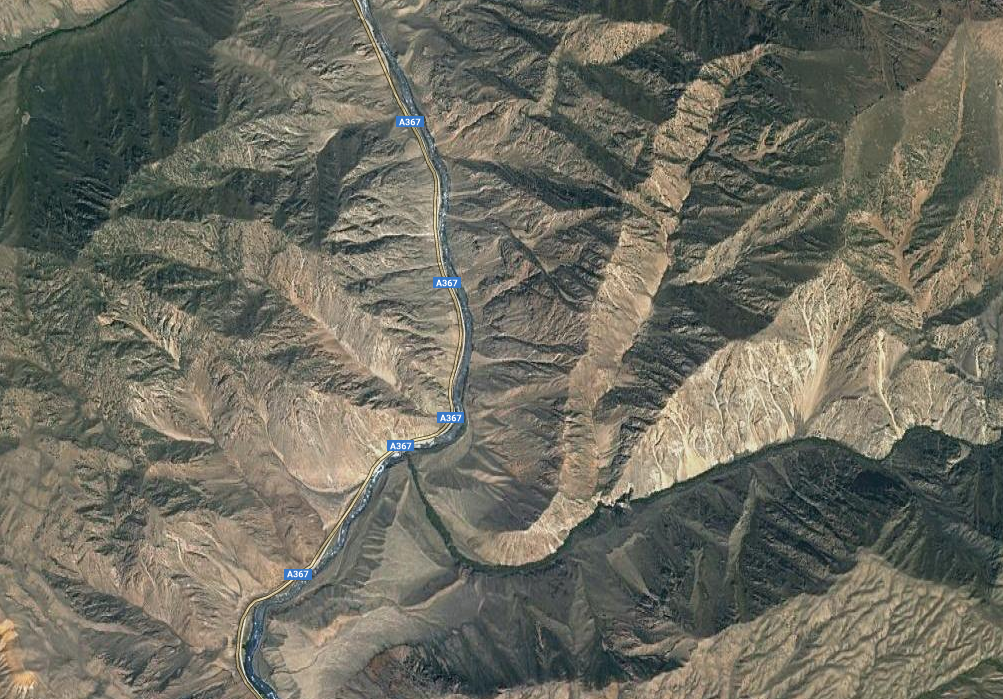
TERRAIN DETAIL: KYZYL OI
(click image to view larger)
Kyzyl Oi is located in the middle of a series of high mountains along the path of the Kokomeren river in a beautiful red rock gorge. Though the surrounding mountains are quite rugged, the roads are not. Driving in the area is easy on a well-maintained graded dirt road that is the main local thoroughfare, making for straightforward navigation as well. The only thing to be aware of is the heavy washboarding in some spots, and the need to be always on the lookout for animals in the unlikeliest of places.
MAP RESOURCES
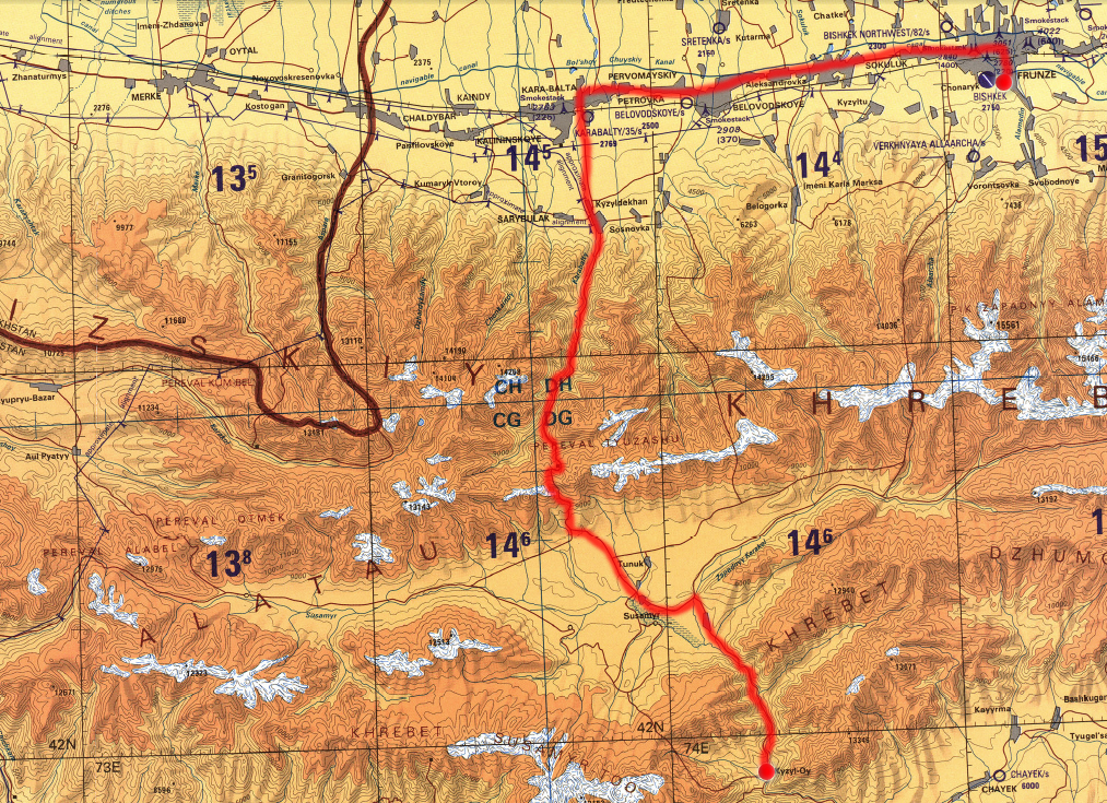
For general planning, a good overview map of Kyrgyzstan that has all the major routes is the GIZI Kyrgyzstan 1:750,000 scale road map. A fairly detailed map, it shows the topography of the mountainous terrain using color to indicate elevation and gives the altitude for some mountain ranges. For more comprehensive topographical information and precise navigational planning US 1:250,000 tactical pilotage maps from the Perry-Castañeda Library Map Collection of the University of Texas at Austin were useful. Note that these maps are “historical” and marked “not to be used for navigational purposes” but they make an excellent planning tool, as the basic topography does not change.
ABOUT THE VEHICLE

This journey was made in a late-model UAZ Patriot sourced from Iron Horse Nomads in Bishkek. This modernized Russian SUV is perfect for Central Asia’s rough roads and mountain passes. Equipped with solid axles front and rear it has plenty of space to carry gear. Powered by a 2.7 gasoline engine, it uses an average of 12-14 liters for a distance of 100 km on the highway and has a 68 liter fuel tank capacity. With 225mm ground clearance, a 5-speed manual transmission and low range transfer case (2wd, 4H, and 4L modes) it is rugged enough for the terrain, yet comfortable. The Patriot is just one of a variety of expedition-ready 4×4 vehicles that Iron Horse Nomads has available for use in Kyrgyzstan, Tajikistan, Kazakhstan and Uzbekistan. Iron Horse Nomads is a unique team of ex-pats and locals working together to encourage people to get out and get to know Central Asia independently. In addition to vehicle rentals, they can assist with planning, logistics, translation and support for overland travel in the region. They also provide service and support to overlanders using personal vehicles in their area of operations.
THE TIEN-SHAN MOUNTAINS
“Tien Shan” is Chinese for “Celestial mountains” and the Tien Shan mountain system stretches in a huge arc 1,200 km long by 300 km across from China through Central Asia, including parts of Kyrgyzstan, Uzbekistan and Kazakhstan. The Tien Shan are a Part of the Himalayan orogenic belt, which was formed by the collision of the Indian and Eurasian plates in the Cenozoic era, they are one of the longest mountain ranges in Central Asia and stretch some 2,900 kilometers (1,800 mi) eastward from Tashkent in Uzbekistan. One of the highest mountain regions in the world, Tien Shan is also one of the most inaccessible. The tallest peaks in the Tien Shan are a central cluster of mountains forming a knot, from which ridges extend along the boundaries between China, Kyrgyzstan, and Kazakhstan. The highest peak is Pobeda or Jengish Chokusu (also called Victory Peak) on the border of China. At 7,439 meters (24,406 ft) high, it is the highest point in Kyrgyzstan. The Tien Shan’s second highest peak, Khan Tengri (Lord of the Spirits), straddles the Kazakhstan-Kyrgyzstan border and at 7,010 meters (23,000 ft) is the highest point of Kazakhstan. Mountaineers class these as the two most northerly peaks over 7,000 meters (23,000 ft) in the world. There are more than 100 peaks over 5000-6000 meters many of which remain unclimbed. The Tien Shan is sacred in Tengrism, and twe Western Tien Shan was just inscribed as a UNESCO World Heritage site in 2016. Tien Shan lay astride the Silk Road, connecting China to the west. The Torugart Pass, at 3,752 meters (12,310 ft), is located at the border between Kyrgyzstan and China’s Xinjiang province. The Tien Shan are separated from the Tibetan Plateau by the Taklimakan Desert and the Tarim Basin to the south. It links up with the Pamir Mountains and to north and east it meets the Altai Mountains of Mongolia. Continuous permafrost is typically found in the Tien Shan starting at the elevation of about 3,500-3,700 m above the sea level. Glaciers in the Tien Shan Mountains have been rapidly shrinking and have lost 27%, or 5.4 billion tons annually, of its ice mass since 1961 compared to an average of 7% worldwide. It is estimated that by 2050 half of the remaining glaciers will have melted. The relief is characterized by a combination of mountain ranges and intervening valleys and basins trending generally from east to west. The ranges are of the alpine type, with steep slopes; glaciers occur along their crests. The Kyrgyz Ala (Qyrghyz) and Talas Alataū ranges, rising above 13,000 feet (4,000 metres) and located farther west, also belong to the outer chain of the northern Tien Shan. There is a great difference in elevation between these outer mountain ridges and the plains at their base. Streams, therefore, usually plunge down the mountain sides through deep gorges and, as they flow out onto the plains, form vast fan-shaped deposits of silt and mud. The fertile land created in the process typically is the site of the population centers.
THE PAMIR HIGHWAY
The Pamir Highway (or “Pamirsky Trakt in Russian) is officially designated as the M-41 and traverses the Pamir Mountains through Afghanistan, Uzbekistan, Tajikistan, and Kyrgyzstan in Central Asia. M41 was the Soviet road number and is no longer signposted along the road. It is the only continuous route through the difficult terrain of the mountains and serves as the main supply route to Tajikistan’s Gorno-Badakhshan Autonomous Region. In use for millennia, the route itself was one link of the ancient Silk Road. The Pamirs sit at the junction of three great mountain ranges, the Hindu Kush, Tien Shan and the Karakorum, and constitute a huge land mass over 3,700m. Most of the Parmir is in neighboring Tajikistan though a section crosses into southern Kyrgyzstan. The Pamir Highway is the second highest altitude international highway in the world (4,655 m). The roadway is unpaved in some areas, but otherwise paved most of the way. Construction and maintenance levels vary substantially and except for its stretches in Kyrgyzstan and nearing Dushanbe, the road is heavily damaged in most of its length by erosion, earthquakes, landslides, and avalanches. Driving the historical Pamir Highway is an excellent challenge for 4×4 adventure travelers however it is important to be aware of some important safety factors. The drive should not be attempted in severe weather conditions. Also, some sections of the road are at very high elevations and altitude sickness can be a concern. A good starting point for anyone planning a Pamir Highway drive can be found at Caravanistan.
POPULATION
The population of Kyrgyzstan is divided among three main groups: the indigenous Kyrgyz, the Russians who remained after the end of the Soviet Union, and a large concentration of Uzbeks. The rest of the population is composed of about eighty other nationalities, with the Uygurs being the most significant. Because of the country’s mountainous terrain, population tends to be concentrated in relatively small areas in the north and south, each of which contains about two million people. About two-thirds of the total population live in the Fergana, Talas, and Chu valleys. As might be expected, imbalances in population distribution lead to extreme contrasts in how people live and work. In the north, The Chu Valley in the north, which includes the capital Bishkek, is the major economic center, producing about 45 percent of the nation’s gross national product. The direct distance from Bishkek in the far north to Osh in the southwest is slightly more than 300 kilometers, but the mountain road connecting those cities requires a drive of more than ten hours in summer conditions; in winter the high mountain passes are often closed. In the Soviet period, most travel between north and south was by airplane, but fuel shortages that began after independence have greatly limited the number of flights, increasing a tendency toward separation of north and south. The separation of the north and the south is clearly visible in the cultural mores of the two regions, although both are dominated by ethnic Kyrgyz. Society in the Fergana Valley is much more traditional than in the Chu Valley. Those in the north tend to be nomadic herders; those in the south have acquired more of the sedentary agricultural ways of their Uygur, Uzbek, and Tajik neighbors. Both groups came to accept Islam late, but practice in the north tends to be much less influenced by Islamic doctrine and reflects considerable influence from pre-Islamic animist beliefs. The southerners have a more solid basis of religious knowledge and practice.
EARLY KYRGYZ HISTORY
The modern nation of Kyrgyzstan is based on a civilization of nomadic tribes who moved across the eastern and northern sections of present-day Central Asia, intermixing to become the Kyrgyz people. Stone implements found in the Tian Shan mountains indicate a human presence here some 200,000 to 300,000 years ago, but the first written records of a Kyrgyz civilization appear in Chinese chronicles beginning about 2000 B.C. Always a nomadic people, the Kyrgyz originally inhabited an area of present-day northwestern Mongolia and they were among the raiders who persistently invaded Chinese territory and stimulated the building of the original Great Wall of China in the third century B.C. The Kyrgyz achieved a reputation as great fighters and traders and the heart of their civilization moved northward into the Yenisey and Baikal regions of present-day south-central Siberia. Their first state, the Kyrgyz Khanate, lasted from the sixth until the thirteenth century A.D., expanding southwestward into the eastern and northern regions of present-day Kyrgyzstan and westward into present-day eastern Kazakstan. In this period, the khanate established intensive commercial contacts in China, Tibet, Central Asia, and Persia. At the height of their power, the Kyrgyz conquered the Uygur Khanate forcing it out of Mongolia in A.D. 840, then moved as far south as the Tian Shan range–a position they maintained for about 200 years. By the twelfth century, however, Kyrgyz domination waned and their territory shrunk even while Kyrgyz tribes continued to move across a wide area of Central Asia and mingle with other ethnic groups.
LAYERS OF MOUNTAIN RANGES
The terrain of Kyrgyzstan is defined by the systems of mountain ranges that dominate the landscape. Kyrgyzstan’s average elevation is 2,750 meters, ranging from 7,439 meters at Pik Pobedy (Mount Victory) to 394 meters in the Fergana Valley near Osh. Almost 90 percent of the country lies more than 1,500 meters above sea level. The two main mountain systems, the Tian Shan and Pamir, together occupy about 65 percent of the national territory. The Alay range portion of the Tian Shan system dominates the southwestern crescent of the country, and, to the east, the main Tian Shan range runs along the boundary between southern Kyrgyzstan and China before extending farther east into China’s Xinjiang Uygur Autonomous Region. Within the Tien Shan are a number of named ranges which are often mentioned separately. In Kyrgyzstan the main line of the Tien Shan continues as Narat Range from the base of the Borohoros west to the point where China, Kazakhstan and Kyrgyzstan meet. This is the highest part of the range – the Central Tien Shan, which contains Peak Pobeda (in the Kakshaal Too range) and Khan Tengri. West of this, the Tien Shan split into an ‘eye’, with the lake Issyk Kul in its center. The south side of the lake is the Terskey Alatau and the north side the Kyungey Ala-Too. West of the eye, the range continues as the Kyrgyz Ala-Too, separating the provinces of Chuy and Naryn. South of the Talas River is the Talas Ala-Too Range (‘Ala-too’ is a Kirgiz spelling of Alatau), and at the east end of the Talas Alatau the Suusamyr Too range runs southeast enclosing the Suusamyr Valley. Another group of mountains curve west-southwest from Issy Kul Lake separating the Tarim Basin from the Fergana Valley. The Fergana Range runs northeast towards the Talas Ala-Too and separates the upper Naryn basin from Fergana proper. The southern side of these mountains merge into the Pamirs.
CLIMATE
The country’s climate is influenced chiefly by the mountains, Kyrgyzstan’s position near the middle of the Eurasian landmass, and the absence of any body of water large enough to influence weather patterns. Those factors create a distinctly continental climate that has significant local variations. Although the mountains tend to collect clouds and block sunlight (reducing some narrow valleys at certain times of year to no more than three or four hours of sunlight per day), the country is generally sunny, receiving as much as 2,900 hours of sunlight per year in some areas. The same conditions also affect temperatures, which can vary significantly from place to place. In January the warmest average temperature (-4°C) occurs around the southern city of Osh, and around Issy-Köl. The latter, which has a volume of 1,738 cubic kilometers, does not freeze in winter. Indeed, its name means “hot lake” in Kyrgyz. The coldest temperatures are in mountain valleys. There, readings can fall to -30°C or lower; the record is -53.6°C. The average temperature for July similarly varies from 27°C in the Fergana Valley, where the record high is 44°C, to a low of -10°C on the highest mountain peaks. Precipitation varies from 2,000 millimeters per year in the mountains above the Fergana Valley to less than 100 millimeters per year on the west bank of Issy-Köl.
KYRGYZ CITIES OF THE DEAD
The Kyrgyz ancestral cemeteries can often be found in desolate weed-covered spots, on the outskirts of villages. Graves, like natural springs, are considered holy places . Cemeteries stand out on hilltops, and graves are marked with elaborate buildings made of mud, brick, or wrought iron. The “mazar” are homes for the spirits of the deceased. According to one Kyrgyz belief death is the only time that a nomad settles down and a nice permanent home must be built for their spirit. Historically spirit houses were built mostly of mud brick. It was believed that the dead lived there and watched over their descendants until the structures eroded and they were freed. Now many are built of real brick, and it is suggested that since the Kyrgyz now live in permanent homes they want their spirits to live in permanent homes too. The older burial structures often combine nomadic, Islamic and Soviet references into a unique aesthetic. The monuments are sometimes crumbling or seem to have been abandoned as it is not Kyrgyz tradition for the living to visit the graves of their dead. Examples of ancient burial sites in Kyrgyzstan range from simple burial mounds to grand mausoleums. The earliest grave markers are probably the balbals (most probably from a Turkic word meaning “ancestor”), anthropomorphic stone stelae. Many of the later mausoleums are in the shape of small citadels complete with walls and towers, and often topped with a dome. Some have a marquee made from clay bricks in fancy patterns and others are adorned with the crescent moon of Islam. A more recent motif includes ironwork in the shape of a yurt erected over the gravesite.
NOTE: This is the first in a series of segments highlighting details of a week-long scouting trip in Kyrgyzstan. All text and photos are copyright JoMarie Fecci/USnomads unless otherwise noted. If you would like to use any imagery here, please contact us for permission. The trip was conducted in September-October 2017 by JoMarie Fecci of US Nomads with support from the Bishkek-based Iron Horse Nomads team. For more information about the specifics contact us.