
OMDURMAN, SUDAN (5 April 2018) — We left Khartoum early this morning but had several stops before reaching the desert highway. I am traveling with Sami and Gammal, and our small team needed to get some supplies at the sprawling market in Omdurman. Then we needed to air up our spare tire, so we made another stop at some sort of garage that had a large air compressor. And finally, our last stop was at the camel market.
The camel market was totally my idea, and a bit of a whim, but I had heard there was a camel market in Omdurman and I thought it might be interesting.
Omdurman is part of greater Khartoum, but it is also a city in its own right, and stylistically it has an older more traditional feel than Khartoum or Khartoum North. The area is known for its market and the Mahdi’s tomb. The camel market is just a touristic footnote.
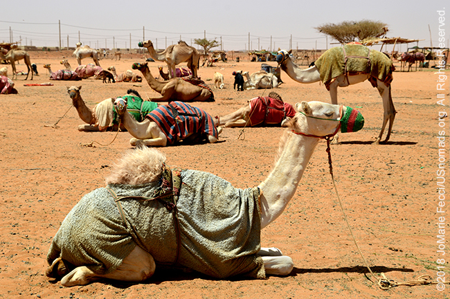
I don’t know what I was expecting exactly, but it was certainly not this. We rolled into a dusty field on the outskirts of town, and at first glance I thought maybe it was a kind of spread out shanty town, as there were plenty of structures in various states of “permanence”. And of course there were camels. But in my mind I had expected pens full of camels in herds, the way you would see sheep or goats or cows even, with buyers and sellers haggling over details. However, here the camels were kind of just randomly tied down without any kind of obvious “vendors,” or buying-and-selling activity going on at all.
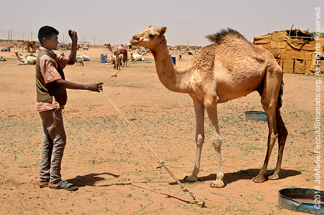
Still, it was interesting visually, maybe even more so because of its “randomness” and so I started to make a few photos of the camels. Some of them were wearing sweaters and others had colorful knitted muzzles on — an item I had never seen on a camel before. Eventually a young man came out and shyly tried to help me get the camels to pose. The group of camels I was photographing belonged to his family. Nomads from Kordofan, they trained racing camels. He began to show some of the animals, talking about their qualities, and I hoped he didn’t think I was in the market to “buy.” Feeling a bit sorry that I had disturbed his morning, I tried to apologize, but he made it clear that it was OK. He didn’t mind chatting with us, and he explained that the “muzzles” were to prevent the camels from grazing. Racing camels should not be too fat, and if left to themselves they would just eat from the trees and everywhere around.
I was interested in the idea of racing camels, and he added matter-of-factly that they usually have races here on Friday mornings. I asked if I would be welcome to come watch and he said sure, emphasizing that they started early, around 7am. I made a mental note of it, and if all goes well I will be returning to Khartoum on a Thursday, so in theory could “attend” the camel races then. We said good-bye and I was glad for the encounter and the chance to learn something new.
As for “market” activity there, it seemed quiet, and I don’t know if it is not the right season or time of day or something else but there wasn’t much more to see at the “camel market” today, so we continued the drive into the desert…
ABOUT THE EXPEDITION
JoMarie Fecci, of USnomads, sets off on an independent scouting trip across Egypt and Sudan in preparation for an up-coming Sahara expedition. Driving locally-sourced Toyotas and working with small local teams in each region, she will traverse a winding route that jumps off from key points along the Nile as far south as Khartoum, where the Blue and White Niles meet. During the journey she will visit a series of UNESCO world heritage sites focused on the ancient civilizations that occupied the region and meet with local communities. The primary goal of this mission is to assess terrain, security, driving conditions, logistical concerns and approximate timeframes for future travel.
WHERE WE ARE
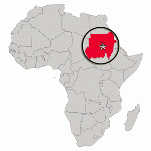
The Sudan in Northeast Africa is bordered by Egypt to the north, the Red Sea, Eritrea and Ethiopia to the east, South Sudan to the south, the Central African Republic to the southwest, Chad to the west and Libya to the northwest. The country has a total area of 1.861.484 square kilometres (718.722 square miles), making it the third largest in Africa. The terrain is generally flat plains, broken by several mountain ranges. In the west the Deriba Caldera (3,042 m or 9,980 ft), located in the Marrah Mountains, is the highest point in Sudan. In the east are the Red Sea Hills. The name Sudan derives from the Arabic “bilād as-sūdān” or “the lands of the Blacks.” The population of roughly 37 million people is made up of 597 different ethnic or tribal groups speaking over 400 different languages and dialects. Sudanese Arabs are by far the largest ethnic group, estimated to account for 70% of the population. They are almost entirely Muslims. The majority speak Sudanese Arabic, with some different Arabic dialects, while many Arabized and indigenous tribes like the Fur, Zaghawa, Borgo, Masalit and some Baggara ethnic groups, speak Chadian Arabic. The nation’s official languages are Arabic and English. Sudanese history goes back to Antiquity, when the Meroitic-speaking Kingdom of Kush controlled northern and central Sudan and, for nearly a century, Egypt.