
OLD DONGOLA, SUDAN (6 April 2018) — In the morning we left the dunes and continued across the desert the rest of the way to the ruins of the old city of Dongola. It seemed lost in the middle of nowhere in the desert and it was hard to imagine that there was once an important city there, or to even understand why it would be there surrounded by the Sahara’s sands and not much else.
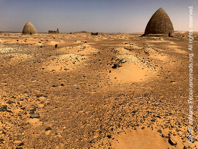
The first thing we saw as we approached were the strange bee-hive shaped domed tombs of a cemetery that is still in use today. These strange tombs marked the graves of important sheiks and religious figures and are from the Islamic period, though according to Sami, there is a unique element of the decoration of the graves here that represents a continuity with the Nubian culture from pre-Islamic times.
The fact that there are pots for offerings and the decorative arrangement of stones in a pattern of black ring filled with white are pre-islamic traditions and distinctly Nubian. We approached one of the beehive shaped tombs and stepped into the darkness, enveloped by the smell of guano. It took a little while for my eyes to adjust, but when they did I could look around and see that there was arabic writing on the wall, some pots and things for offerings, the graves themselves, and everything covered in a “silt” of bat poop. Sami explained that locals often come and collect the guano to fertilize their gardens, and as we walked out, we saw a man entering the next nearest tomb with a bucket to do just that.
I could have stayed and photographed around these tombs for hours, but Sami said there was something “more interesting” to see a bit further on. Looking into the distance I could see a sort of tall square-ish layer-cake-like building on a hill. It marked the location of the old city of Dongola, which pre-dated the Islamic period, and once housed a church.
As we made our way towards it, I could see a few stone columns rising up out of the desert sand. They had once belonged to an older church, and their capitals were lined up at the center of the archaeological site display. The sculpted pieces all had prominent christian crosses, a silent testament to the melange of historical cultures that influenced the people of Nubia since ancient times.
This was once a vibrant and important city that had crumbled into the desert. Its ruins had filled in with wind-blown Saharan sand, and in some places were completely buried. The archaeologists had excavated some of it. The foundations of a fortress wall were clear and went right up to the edge of the desert where it meets the Nile below. Perhaps this was a strategic location on the river. From the heights we could see very far both up and down the Nile, and also out into the desert as far as a distant mountain to the southeast.
I was free to wander the ruins and excitedly walked the ancient alleys between crumbling walls that were once homes or places of business. I wondered how they could tell what things once were. How could they reconstruct history from the ruins? I was just fascinated by this “ghost town” of the Sahara and wandered aimlessly photographing details. Sand piling up against a wooden door. A broken pot in front of a mostly intact house. Rough and rugged mud brick walls crumbling like the eroded rock formations of the Tassili. I wanted to know what happened here. Where did the people go and why did they abandon this place. There is a modern town called Dongola not very far away. When did an entire population displace itself to a new location. So many questions without answers.
After a visit to the big building which was once a monastery and which is now reconstructed but locked (we were able to get the caretaker to come and open it for us), we left the site and made a brief stop to visit a family that Sami knew before continuing on the way to the New city of Dongola.
We decided to take the desert route rather than the paved road, the terrain was mostly flat, but the sand was very soft in some spots. The old desert route had some new surprises. From time to time we had to maneuver around newly established farmland. Wheat fields in the Sahara. It was incongruous but part of the government’s policy of encouraging agriculture here in the north. Apparently families were being encouraged to move into the desert and take up farming with irrigation support in order to compensate for the loss of so much agricultural land in the south. Solar-powered irrigation and hydroponics have made it possible to transform the desert into more arable terrain. Maybe one day this part of Sudan will look a lot like southern California.
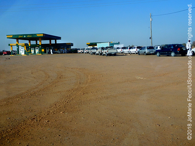
As we got near to the modern town of Dongola we returned to the tar road and went in search of petrol for the truck. There has been a severe gas shortage throughout Sudan since January, and it is kind of vague as to the exact reason, though the guys told me the government says it is due to the fact that one of the major refineries is offline for repairs. Many petrol stations have no gas at all, and the few that do have long long lines of vehicles — some waiting for hours, and in a few cases days, for the delivery of gas or diesel fuel. We were already carrying extra gas, which should be enough to complete the journey, but it was best to refill when we found gas available — even if there was a long line. We took our place on the line, while Sami and Gammal went to see if we could get an “exception” from the security guys as “visitors”. I was hesitant to try to use this status to “cut” the line, but they were insistent that we should try. Eventually it worked somewhat and we didn’t have to wait as long as others. Still, as we waited I was able to observe, even if I was not permitted to make any photographs (the plain clothes “security” presence enforced this rule) — one of the more absurd things I saw while we waited was a donkey towing an out-of-gas vehicle to the gas line.
By the time we had gotten our gas it was very late in the afternoon and we decided to head off into the desert to find a spot to camp not far from the town. It was getting dark already as we reached the low dunes and we had a bit of trouble looking for a good spot to set up when we could not really see very far ahead in the dunes. We chose the first decent spot, a flat-ish spot between some dunes and rocks, and set up quickly under the star-filled sky…
ABOUT THE EXPEDITION
JoMarie Fecci, of USnomads, sets off on an independent scouting trip across Egypt and Sudan in preparation for an up-coming Sahara expedition. Driving locally-sourced Toyotas and working with small local teams in each region, she will traverse a winding route that jumps off from key points along the Nile as far south as Khartoum, where the Blue and White Niles meet. During the journey she will visit a series of UNESCO world heritage sites focused on the ancient civilizations that occupied the region and meet with local communities. The primary goal of this mission is to assess terrain, security, driving conditions, logistical concerns and approximate timeframes for future travel.
WHERE WE ARE
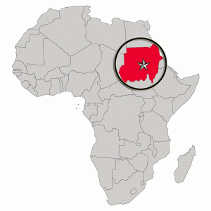
The Sudan in Northeast Africa is bordered by Egypt to the north, the Red Sea, Eritrea and Ethiopia to the east, South Sudan to the south, the Central African Republic to the southwest, Chad to the west and Libya to the northwest. The country has a total area of 1.861.484 square kilometres (718.722 square miles), making it the third largest in Africa. The terrain is generally flat plains, broken by several mountain ranges. In the west the Deriba Caldera (3,042 m or 9,980 ft), located in the Marrah Mountains, is the highest point in Sudan. In the east are the Red Sea Hills. The name Sudan derives from the Arabic “bilād as-sūdān” or “the lands of the Blacks.” The population of roughly 37 million people is made up of 597 different ethnic or tribal groups speaking over 400 different languages and dialects. Sudanese Arabs are by far the largest ethnic group, estimated to account for 70% of the population. They are almost entirely Muslims. The majority speak Sudanese Arabic, with some different Arabic dialects, while many Arabized and indigenous tribes like the Fur, Zaghawa, Borgo, Masalit and some Baggara ethnic groups, speak Chadian Arabic. The nation’s official languages are Arabic and English. Sudanese history goes back to Antiquity, when the Meroitic-speaking Kingdom of Kush controlled northern and central Sudan and, for nearly a century, Egypt.