
SAI ISLAND, SUDAN (7 April 2018) — A bit of a marathon drive day today from Dongola to Abri, with an amazing finish on the island of Sai. The tar road north across the legendary gold fields of Nubia was well-maintained and we moved fast. I had no idea of the magical place that awaited us.
This morning we were quick to break camp and get on the road. I did spend a little bit of time exploring around the area where we camped and found a few pottery shards, though it was not an archaeological site. It made me wonder a bit about how they determined what was a “site” and what was just old garbage. Is it about the age of the debris or its location or the importance of the “town” that was in a place that makes it worthy of the term “artifact”?
In any case, we had a lot to accomplish, and we started off with a short visit to the Western Deffufa a huge tower-like structure that on first glance looked like a rock formation rather than a man-made edifice. Below it was a strange pattern of earthworks that I thought might have some kind of symbolic significance. As I wandered around the site, Sami explained that the earthworks were actually a reconstruction of the foundations of the complex that once surrounded the tower.
A “deffufa” is something unique to Nubian Architecture, and is a kind of temple or religious structure. There are only three known deffufas in existence: the Western Deffufa, the Eastern Deffufa and a smaller third one. The largest, the “Western Deffufa” is located in the heart of what was once the kingdom of Kerma and is around 9,500 years old. The word “deffufa” is either derived from the Nubian term for a mud-brick building or from the Arabic word “daffa,” meaning “mass” or “pile.” Today it looks like a mysterious eroded rock pillar surrounded by alien earthworks. As we approach, a strange and surreal sound emanating from the monument, makes it seem oddly “alive.” It is the chirping of hundreds of birds who have made homes in the cracks and crevices of the crumbling tower.
We can climb up to the top of the tower and look across the desert into infinity with only a hint of some far off mountains to define the horizon. Beyond the site there is a museum that contains some important artifacts uncovered at this site, including a group of Egyptian statues that had been purposely buried here.
It was strange to be exploring these “sites” that seemed to be opened just for my visit and locked back up once I left. I imagined they were scheduled to be open when tour or school groups would come, but otherwise probably only open by “appointment.”
After the Deffufa, we picked up the tar road heading north towards Abri, a journey of roughly 200 km. The road would take us through the “gold fields” where mining companies and private individuals were digging in hopes of finding their fortune. It was a bit unclear to me who had the rights to dig and who was just “prospecting” and what was actually legal, but there was definitely a sense of nervousness in some of the men we passed. Notably at one gas station line where we stopped to try to get gas for the boatman at Abri a truck of agitated young men seemed on the verge of violence when they cut the line to fuel their old truck. The truck looked like something out of the film “The Sorcerer” and had ostrich plumes decorating the hood. I could not take any photos because of the gas line security men.
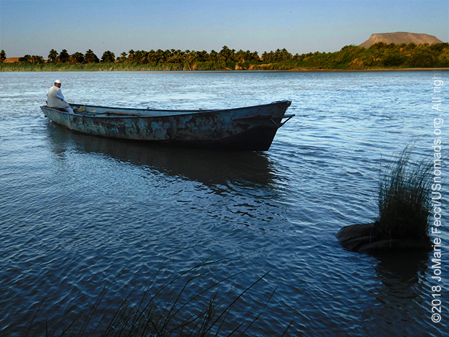
We reached Abri late in the afternoon, having succeeded in getting the boatman’s gas, and made a few stops around town for supplies before heading to the ferry “dock.” I wasn’t really sure what to expect in terms of a “ferry.” It would be taking us across the Nile to an island that is in between the river’s banks. The distance wasn’t long, but we had to get the Toyota across the mighty river. I didn’t imagine it would be a giant vehicle transport ferry like we have in the U.S., but figured it had to be a big enough boat to hold a truck. It couldn’t be just one of the many wooden boats we have seen on the river until now.
The “dock” wasn’t an actual “dock” at all, just a clearing in the bush with a sloping dirt “ramp” down into the river. The “ferry” was a large-ish flat metal boat which could fit a couple of vehicles and a few additional passengers. I quickly understood that it would not be a “quick” process, as they explained that they had been stuck on the other side for several hours trying to get a truck off the boat. Sami suggested we let Gammal handle getting the Toyota across on the ferry while we went with one of the taxi boatmen so that I would be able to benefit from the beautiful late afternoon light.
We boarded the smaller low wooden boat and the boatman powered his motor and we were off, cruising the Nile in anonymity like river pirates. I smiled as the cool breeze blew across my face, and thought to myself that this was a much better “Nile Cruise” than the Egyptian tourist offering. We moved swiftly downriver past some smaller islands with sandy beaches, and the boatman spotted a couple of crocodiles sunning on a rock. I was able to get a distant photo of them before they jumped into the water as we tried to approach.
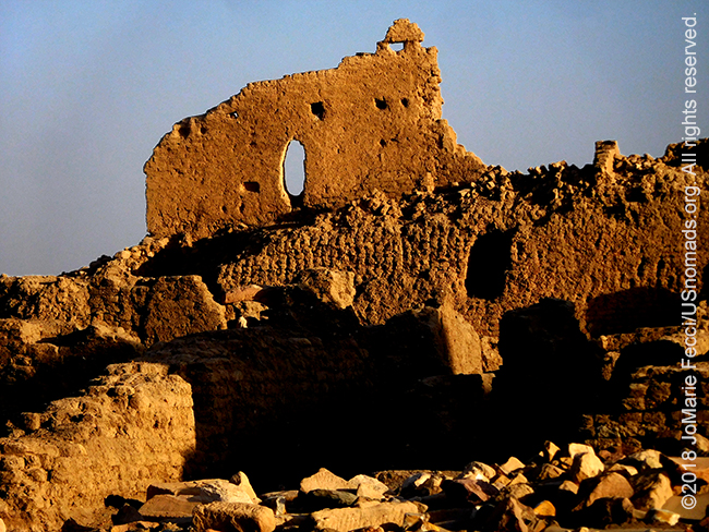
As the Nile bent around a curve I got my first glimpse of the island of Sai, and the rough edged silhouette of ruins that overlooked the river. It was surreal. The light was transforming the crumbling rock walls into a golden colored citadel that seemed to crown the cliffs. This was our landing point and our base-camp for the night. We pulled up to a small clearing at the base of the cliff and exited the boat to climb up a narrow footpath to the ruined city at the top. Looking back across the Nile I could see the boatman powering his motor and turning back towards the river bank. The sun was almost setting on the ruins and it was beautiful …
ABOUT THE EXPEDITION
JoMarie Fecci, of USnomads, sets off on an independent scouting trip across Egypt and Sudan in preparation for an up-coming Sahara expedition. Driving locally-sourced Toyotas and working with small local teams in each region, she will traverse a winding route that jumps off from key points along the Nile as far south as Khartoum, where the Blue and White Niles meet. During the journey she will visit a series of UNESCO world heritage sites focused on the ancient civilizations that occupied the region and meet with local communities. The primary goal of this mission is to assess terrain, security, driving conditions, logistical concerns and approximate timeframes for future travel.
WHERE WE ARE
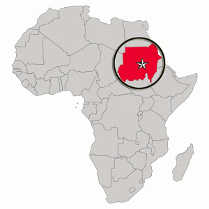
The Sudan in Northeast Africa is bordered by Egypt to the north, the Red Sea, Eritrea and Ethiopia to the east, South Sudan to the south, the Central African Republic to the southwest, Chad to the west and Libya to the northwest. The country has a total area of 1.861.484 square kilometres (718.722 square miles), making it the third largest in Africa. The terrain is generally flat plains, broken by several mountain ranges. In the west the Deriba Caldera (3,042 m or 9,980 ft), located in the Marrah Mountains, is the highest point in Sudan. In the east are the Red Sea Hills. The name Sudan derives from the Arabic “bilād as-sūdān” or “the lands of the Blacks.” The population of roughly 37 million people is made up of 597 different ethnic or tribal groups speaking over 400 different languages and dialects. Sudanese Arabs are by far the largest ethnic group, estimated to account for 70% of the population. They are almost entirely Muslims. The majority speak Sudanese Arabic, with some different Arabic dialects, while many Arabized and indigenous tribes like the Fur, Zaghawa, Borgo, Masalit and some Baggara ethnic groups, speak Chadian Arabic. The nation’s official languages are Arabic and English. Sudanese history goes back to Antiquity, when the Meroitic-speaking Kingdom of Kush controlled northern and central Sudan and, for nearly a century, Egypt.