
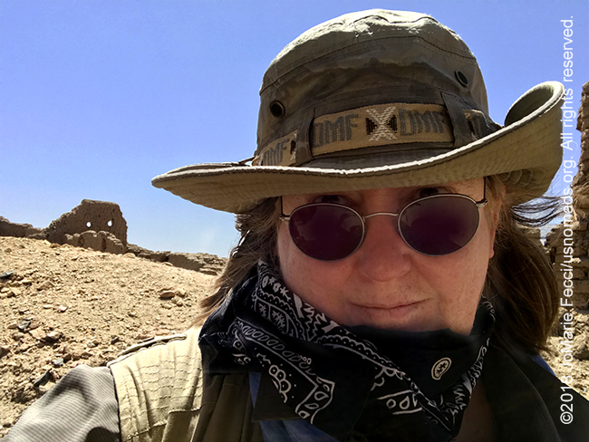
WAWA, SUDAN (8 April 2018) — The morning breeze was cool and refreshing as I watched the river from my perch outside the archaeological compound at Sai Island. Last night I stayed up a bit late just looking at the stars, while the guys spent some time with Sami’s friends from the mission. He had worked on this site for several months and knew the caretaker’s whole family. The rest of the archaeological team was on leave and apart from the caretaker and his family we had the whole site to ourselves.
I went for a bit of a wander on the edge of the ruins, then Sami suggested we take the truck and drive over to the mountain. Sai mountain is the tallest point on the island and after driving up most of the way, we did the last bit on foot. From the top we could see 360 degrees around, and down to several modern villages that still exist on the island. This place has been continuously inhabited since pre-historic times. Last night we drove over to a place with giant earthen tombs that date to the “pre-historic” period, and Sami pointed out that same “pattern” of black and white stones in a circle marking the grave. There was this link between past and present.
For me the whole island was like that link. Everywhere there were archaeological sites and I was free to walk around and explore as if I was discovering it for the first time. Back down among the rubble I took my time to photograph and really look at the remains of a civilization. The pottery shards that littered the landscape were not being gathered into a museum collection. Some were crushed underfoot as we walked the ancient street. I wondered how they determined what needed to be preserved and protected and what was so ordinary it held no value. And how do they determine the dates of things for a location that was continuously inhabited. I felt like I was a student again. Learning the basics of the archaeologists’ profession.
A cool breeze blew through the deserted streets of an ancient ghosttown as I picked my way over the rubble. I was trying to reach the jagged wall that was so prominent when we approached from the river. I walked where I could safely move without creating an avalanche of crumbled ruins. So many questions floated through my mind. Was this once someone’s home, or were these buildings more utilitarian constructions for workshops or public spaces. Maybe they were military or religious in nature as those two aspects of life were always “funded” even when people were living in huts. My questions remained unanswered, but I made it to the edge of the precipice where the Ottoman era fortress had stood. Its remaining walls were still quite solid and the dramatic shape of the ruin made it remarkable, almost shining in the morning sun.
Beyond the ruins, further into the interior of the island I came across some current excavation sites. These looked very different than the huge holes that were dug around some of the other gravesites we had seen. The big holes were the work of prospectors or grave robbers — people looking for gold. Here at the excavation site there were no “holes”, instead the sand was removed or brushed away leaving any artifacts exposed in place. It was like a crime scene with numbered plaques by each piece of evidence. A few bones in one spot. In another some more intact remains included a couple of skulls and other bones. Who were these dead men (or women) and what was their story? More questions that remained unanswered. The archaeologists working here are trying to piece together these stories, but for the moment there are just very vague outlines.
For me it is always so curious to see places like this where vibrant cities and civilizations have existed for centuries and yet the modern population abandoned the old place at some point, just leaving it as it was, and moved on to someplace new. Sometimes they would use the old bricks and stones to construct new towns. Other times the old sites were just left to the desert sands to cover and reclaim or not.
We had to leave Sai Island around noon, when the ferryman would come back to take us across the Nile again. Normally this is not a big deal, but because of the gas shortage the boat would only make one or two trips a day, and we needed to be on the one at noon or we would not have enough daylight to go much further. As we rolled up to the clearing where the ferry docked we could see a huge truck stuck in the sand trying to back onto the loading ramp. Its rear driver’s side tire was spinning deep in a hole. A group of men were working to get it moving. Some were digging. Others were directing the operation and the whole group pushed in unison with each attempt.
Apparently this was a frequent occurrence and no one seemed terribly concerned. Eventually they got the truck onto the boat and it was our turn. Once we were all on the boat, the ferry pushed off and chugged slowly for the short distance to the other bank of the Nile. Sami mentioned that the engine seemed quiet and it turned out that the normal big diesel engine that usually powered the ferry was silent. The ferryman explained to us that it was not possible to get enough diesel fuel to operate it, so he had rigged up an alternative system with two outboard motors that ran on gas. The two motors were small but together they were capable of powering the boat well enough to make the crossing. I marvelled at the ingenuity of the people. Their ability to cope and find solutions to the most absurd situations was amazing. The most surreal scenarios were no match for their creative thinking. Nothing was impossible even when nothing worked the way it was supposed to.
As we drove up the bank of the Nile near Abri it was already well into the afternoon. We made our way to Wawa to a guest house where we would stay the night. Then after getting organized and settling in, we took off again back towards the Nile. This time we were with two quiet young men who guided us to a field where we needed to park the truck and then continue on foot the rest of the way to the river’s edge where a small boat was waiting. The men helped us down into the boat, then silently pushed off and we motored along towards somewhere unknown on the other bank.
The mighty Nile was dark and the boat was low in the water and I felt somewhat adventurous as the men guided the boat towards a non-descript spot amidst a tangle of brush. They secured the boat and I could see a small footpath between the bushes. We followed it up and across a field where a woman was working in coolness of the late afternoon shadows, and then I could see the forms of a great temple poking up beyond the thick brush. We were approaching the temple of Soleb. An enormous edifice built by the Egyptians in what is now a modest town. The sun was low in the sky and the temple was a golden orange in color. Much of it was still intact and it was truly awe-inspiring to walk through it.
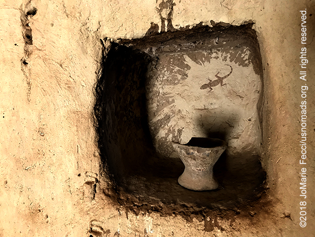
I explored a bit and photographed the ephemeral beauty as the sun’s rays colored the stone with a magical light. While I was wandering around the temple two more men joined our small group, and invited us to continue along with them to a hidden chapel in the rock face that overlooked the Nile. The six of us piled into a van with local music blaring and drove through the town to a big dune abutting a rocky cliff. Three little girls were playing on the dune, but our presence seemed more interesting, and soon they were added to our entourage as we continued on foot to the location of the hidden “chapel.” I had to climb up a small ledge on the cliff to the entrance of a shallow cave. Inside the statues carved into the wall were the likenesses of Egyptian gods and a pharaoh.
I wondered who had carved them and why. There was the huge temple nearby. What role did this small cave play? I could invent so many stories in my head to explain it, but what was the truth? No one could answer that question. It would remain a mystery, like so many of the details here.
The sun had set while we were at the cave, and as we made our way back towards the boat darkness was settling in. We didn’t have flashlights, but we did have our phones to light the way over the field and through the bush. Our group had dwindled to just Sami and myself and the two young boatmen. As the men pushed off and fired up the motor the wooden boat slipped easily along the Nile, the first stars reflected in the dark water and a gentle breeze accompanied us. I felt like some kind of smuggler, in a single small low boat, making my way unseen to an invisible point in the mass of brush beside an anonymous field “somewhere” along the Nile in Sudan…
ABOUT THE EXPEDITION
JoMarie Fecci, of USnomads, sets off on an independent scouting trip across Egypt and Sudan in preparation for an up-coming Sahara expedition. Driving locally-sourced Toyotas and working with small local teams in each region, she will traverse a winding route that jumps off from key points along the Nile as far south as Khartoum, where the Blue and White Niles meet. During the journey she will visit a series of UNESCO world heritage sites focused on the ancient civilizations that occupied the region and meet with local communities. The primary goal of this mission is to assess terrain, security, driving conditions, logistical concerns and approximate timeframes for future travel.
WHERE WE ARE
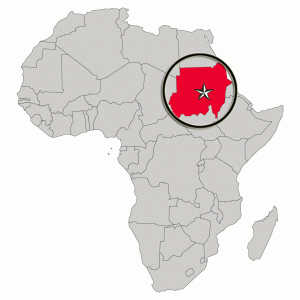
The Sudan in Northeast Africa is bordered by Egypt to the north, the Red Sea, Eritrea and Ethiopia to the east, South Sudan to the south, the Central African Republic to the southwest, Chad to the west and Libya to the northwest. The country has a total area of 1.861.484 square kilometres (718.722 square miles), making it the third largest in Africa. The terrain is generally flat plains, broken by several mountain ranges. In the west the Deriba Caldera (3,042 m or 9,980 ft), located in the Marrah Mountains, is the highest point in Sudan. In the east are the Red Sea Hills. The name Sudan derives from the Arabic “bilād as-sūdān” or “the lands of the Blacks.” The population of roughly 37 million people is made up of 597 different ethnic or tribal groups speaking over 400 different languages and dialects. Sudanese Arabs are by far the largest ethnic group, estimated to account for 70% of the population. They are almost entirely Muslims. The majority speak Sudanese Arabic, with some different Arabic dialects, while many Arabized and indigenous tribes like the Fur, Zaghawa, Borgo, Masalit and some Baggara ethnic groups, speak Chadian Arabic. The nation’s official languages are Arabic and English. Sudanese history goes back to Antiquity, when the Meroitic-speaking Kingdom of Kush controlled northern and central Sudan and, for nearly a century, Egypt.