
< more recent | 22-31 July 2018 | older >
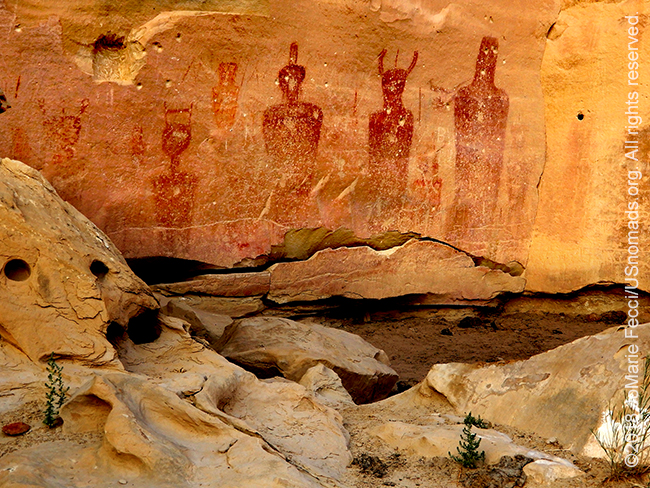
31 July 2018: Headed north of Moab today to check out Sego Canyon where there are several excellent examples of rock art spanning a large period and also the remains of an old coal mining town–which is unusual in this area. …
30 July 2018: Went exploring around the Needles this afternoon, taking the time to revisit a less familiar region of the Canyonlands National Park. The smoke from the California wildfires created a haze that dulled the colors and hindered visibility, but the natural beauty of this area of the park still managed to shine through …
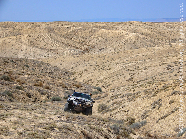
29 July 2018: Made a quick trip to Grand Junction to do some intensive desert driving under the watchful eye of Bill Burke who prepared some very challenging exercises across a variety of terrain. Working with a long wheelbase Toyota pickup that had no lift, no lockers and a manual transmission made it even more “interesting” and helped sharpen skills on complex terrain. The vehicle configuration was quite similar to what we can find in the Sahara, so it was an excellent simulation of some of the difficulties of maneuvering across technical terrain without all the benefits of a modified Jeep …
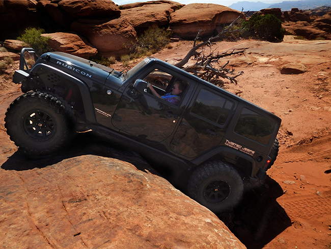
28 July 2018: An awesome day on some fun and challenging Moab trails with K.L. Young of Twisted Jeep today. Got to experience Metal Masher for the first time (did not attempt Widowmaker though), and finished up with a scenic route through Long Canyon,and back via Shaefer and Potash Road. With such a nicely modified Jeep (Rubicon with a 4″ lift on Yokohama 37s) the trail was almost “easy” …
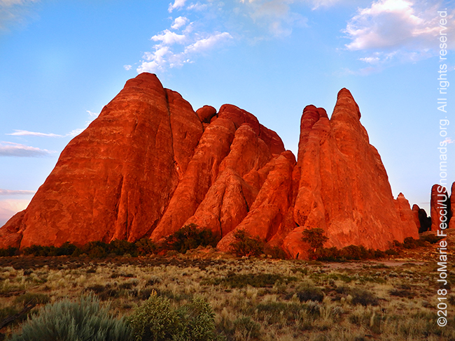
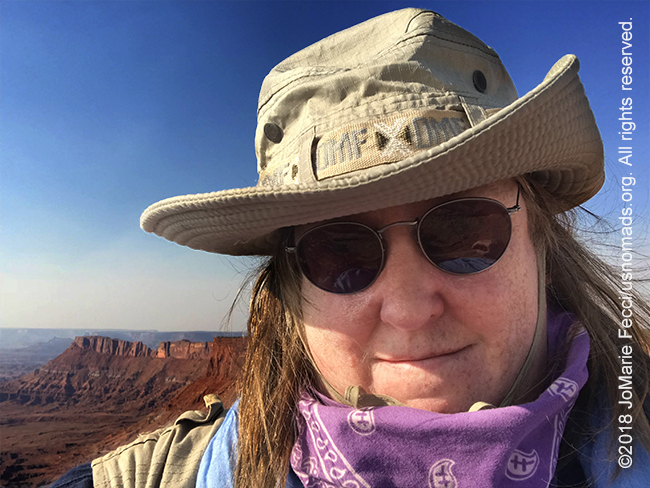
27 July 2018: So good to be back in the land of redrock and blue skies — even if there is a bit of haze coming from the California wildfires, the views are still inspirational. Spent the day reconnecting with the landscape and just taking it all in…
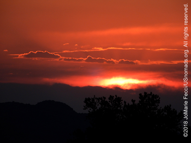
26 July 2018: Back on the road and back in the southwest, heading to a favorite desert place. Reached Moab not long after sunset…
THIS MONTH:

Headed back to Moab for some Jeep fun and red rock exploration. Hitting a few trails and working on desert navigation in a very favorite place…
![]()
Participating in the Ladies Offroad Convention in Salt Lake City, Utah, 2-5 August 2018. The Ladies Offroad Convention is an action-packed, interactive 4-day weekend educating, motivating, and guiding for ladies involved in all aspects of the offroad world. Presented by Charlene Bower and the Ladies Offroad Network, the event creates a space to learn more about offroad activities and share experiences with like-minded women from around the country…
COMING UP SOON:

Heading to a small village in Serbia to help out with the annual plum harvest and spend some time exploring the countryside with friends …
ABOUT SEGO CANYON
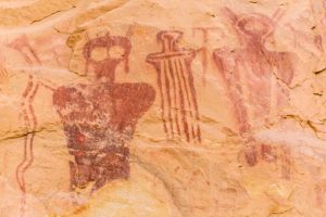
The Sego Canyon Petroglyphs found on the sandstone cliffs indicate a holy place. Native Americans painted and chipped their religious visions, clan symbols, and records of events onto the cliffs. There are three distinct styles present which represent three separate cultures and time periods. The “Barrier Canyon Petroglyphs” (6000 B.C. – 100 B.C.) are attributed to Archaic people. Archaic people were nomads, hunting large and small game animals, collecting and processing wild plants. They did not build permanent habitation structures, but lived in caves and in small brush shelters built in the open. They occupied this area from approximately 8,000 years ago until the introduction of corn agriculture about 2,000 years ago. The Barrier Canyon style of rock art usually consists of larger than life size anthropomorphic (manlike) forms. The identifying characteristic of these figures is hollowed eyes or missing eyes, the frequent absence of arms and legs, and the anthropomorphs with bug-eyes, antennae, earrings, snakes in hand, and leg-less torsos. The “ghost-like” images, may represent shamanistic art associated with ritual activities of the Archaic people. The “Fremont Indian Petroglyphs” (600 A.D. – 1250 A.D.) date to the period when the Fremont Culture thrived and was contemporary with the Anasazi Culture of the Four Corners area. Like the Anasazi, the Fremont planted corn and lived in pithouses and surface stone structures. They constructed a distinctive basketry and made pottery. They had a complex social structure, as is illustrated in their rock art, and were highly adaptive to the extremes of their environment. At the top of the panel are the oldest figures. These are the line of large, red-painted figures with the rectangular-bodies and small-heads, which are similar to the Anasazi Basket maker style. Superimposed on the older, painted figures is a line of carved (pecked) human figures. Typically, these have trapezoids for the head and body. The most recent Freemont period is also represented by superimposed carvings. They are deeply groved outlines of two life-sized human figures with collars and waistbands, and the associated mountain sheep and abstract elements. This last group is representative of the Classic Fremont Style. The “Ute Indian Petroglyphs” (1300 A.D. – 1880 A.D.) are clearly identified and dated by the horse and rider figures. Horses were introduced to North America by the Spanish in the sixteenth century. Other figures, or elements, painted in red and white on the panel include a white bison, a human figure with leggings, several large human figures, and large circles believed to be shields. The Ute people practiced a hunting and gathering lifeway. They used the bow and arrow, and made baskets and brownware pottery, and lived in brush wikiups and tipis. The No-tah (Ute people) lived freely throughout western Colorado and eastern Utah until about 1880, when they were forced onto reservations…
ABOUT ARCHES
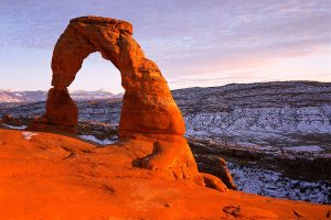
Arches National Park has over 2,000 natural stone arches, in addition to hundreds of soaring pinnacles, massive fins and giant balanced rocks. The park is situated just north of Moab and is bordered by the Colorado River in the southeast. It’s most famous sandstone arch is the red-hued Delicate Arch in the east, but Arches is home to the highest density of natural arches in the world. The national park lies above a salt bed, which transformed the landscape with the formation of the arches, spires, balanced rocks, sandstone fins, and eroded monoliths in the area. The salt bed is thousands of feet thick in places, and was deposited in the Paradox Basin of the Colorado Plateau some 300 million years ago when a sea flowed into the region and eventually evaporated. Over millions of years, the salt bed was covered with debris eroded from the Uncompahgre Uplift to the northeast. During the Early Jurassic desert conditions prevailed in the region and the vast Navajo Sandstone was deposited. An additional sequence of stream laid and windblown sediments, the Entrada Sandstone, was deposited on top of the Navajo. Over 5,000 feet of younger sediments were deposited and have been mostly eroded away. Remnants of the cover exist in the area including exposures of the Cretaceous Mancos Shale. The arches of the area are developed mostly within the Entrada formation. The weight of this cover caused the salt bed below it to liquefy and thrust up layers of rock into salt domes. The evaporites of the area formed more unusual salt anticlines or linear regions of uplift. Faulting occurred and whole sections of rock subsided into the areas between the domes. In some places, they turned almost on edge. As this subsurface movement of salt shaped the landscape, erosion removed the younger rock layers from the surface. Most of the major formations visible in layer cake fashion throughout the park today are the salmon-colored Entrada Sandstone or the buff-colored Navajo Sandstone. Over time, water seeped into the surface cracks, joints, and folds of these layers. Ice formed in the fissures, expanding and putting pressure on surrounding rock, breaking off bits and pieces. Winds later cleaned out the loose particles. A series of free-standing fins remained. Wind and water attacked these fins until the cementing material gave way and chunks of rock tumbled out. Many damaged fins collapsed. Others, with the right degree of hardness and balance, survived despite their missing sections. These became the famous arches …
Nesconset | Paris | Salt Lake City | Moab | Grand Junction | Belgrade

MORE NOTES FROM THE ROAD:
9-21 July – Woman and Machine
1-8 July – DC Dirt Camp
25-30 June – Orienteering
1-24 June – Paris
7-10 June – Bantam Jeep Festival
1-6 June – Roadtrip to Bantam JeepFest
May – Wheelers Overland
16-30 April – New York
4-15 April – Sudan
29 March – 3 April – Egypt
22-28 March – Paris
16-21 March – Paris
1-15 March – New York
February – Coal Country
January – Vegas to Glamis Roadtrip
December – East Coast Roadtrip
16-30 November – Paris
1-15 November – Florida
October – Rausch Creek
18-30 September – Kyrgyzstan
1-17 September – Rebelle U
15-31 August – Arizona
8-14 August – TFT9
1-7 August – Serbia
Archive
REFLECTIONS

A quick overview of impressions from a stop in Cairo during our recent scouting mission in Egypt and Sudan … [read]
SPECIAL REPORT

A look into south-eastern Algeria on the border with Libya and Niger: overlanding with the Tuareg in one of the most remote corners of the Sahara … [read]